Porreres geodata
Porreres (Balearic Islands) is a seat of a third-order administrative division; located in Spain in Europe/Madrid (GMT+2) time zone. With population of 4,597 people, there are 1372 cities with bigger population in this country. Compared to other cities in Spain, 76.7% of cities are located further ↑North; 98.9% of cities are located further ←West and 85.7% of cities have higher elevation than Porreres. Note1


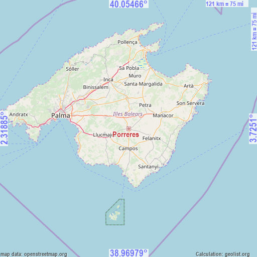
Porreres GPS coordinates[2]
39° 30' 51.624" North, 3° 1' 19.092" East
| Map corner | latitude | longitude |
|---|---|---|
| Upper-left | 40.05466°, | 2.31885° |
| Center: | 39.51434°, | 3.02197° |
| Lower-right: | 38.96979°, | 3.7251° |
| Map W x H: | 120.6×120.6 km | = 74.9×74.9mi |
| max Lat: | 43.74134° ⇑76.7% North |
| Porreres: | 39.51434° |
| min Lat: | ⇓23.3% South 27.64134° |
| min Long | Porreres | max Long |
| -18.00367° | 3.02197° | 4.2899° |
| W 98.9%⇐ | ⇒1.1% E |
Elevation
Elevation of Porreres is 128 m = 420 ft, and this is 470 m = 1542 ft below average elevation for this country.
| Max E: |
1682 m = 5518 ft | 85.7% |
| Avg. | 598 m = 1962 ft | |
| Porreres | 128 m = 420 ft | |
Min E: |
0 m = 0 ft | 14.3% |
See also: Spain elevation on elevation.city.
Geographical zone
Porreres is located in North temperate zone (between Tropic of Cancer and the Arctic Circle). Distance of this Northern Tropic circle is 1787.7 km =1110.8 mi to South.| Distance of | km | miles | from Porreres |
|---|---|---|---|
| North Pole | 5613.5 | 3488.1 | to North |
| Arctic Circle | 3007.6 | 1868.8 | to North |
| Tropic Cancer | 1787.7 | 1110.8 | to South |
| Equator | 4393.6 | 2730.1 | to South |


Nearby cities:
15 places around Porreres: (largest is in red/bold)
• Algaida
11.9 km =7.4 mi,  294°
294°
• Ariany
16.9 km =10.5 mi,  26°
26°
• Campos
9.3 km =5.8 mi,  181°
181°
• Costitx
17 km =10.6 mi,  338°
338°
• Felanitx
11.9 km =7.4 mi,  114°
114°
• Lloret de Vistalegre
12.2 km =7.6 mi, 340°
• Llucmajor
11.5 km =7.1 mi,  256°
256°
• Manacor
17.2 km =10.7 mi,  69°
69°
• Maria de la Salut
17.1 km =10.6 mi,  14°
14°
• Montuïri
6.8 km =4.2 mi,  329°
329°
• Petra
13.5 km =8.4 mi,  35°
35°
• Sa Ràpita
17.9 km =11.1 mi,  202°
202°
• Sant Joan
9.2 km =5.7 mi, 9°
• Sineu
14.3 km =8.9 mi,  356°
356°
• Vilafranca de Bonany
8.3 km =5.2 mi, 43°
Sources, notices
• [Note1] Compared only with cities in Spain existing in our database
• [Src1] Map data: © OpenStreetMap contributors (CC-BY-SA)
• [Src2] Other city data from geonames.org with taken over terms of usage.
• [Src3] Geographical zone / Annual Mean Temperature by Robert A. Rohde @ Wikipedia
