Manacor geodata
Manacor (Balearic Islands) is a seat of a third-order administrative division; located in Spain in Europe/Madrid (GMT+2) time zone. With population of 40,548 people, there are 218 cities with bigger population in this country. Compared to other cities in Spain, 76% of cities are located further ↑North; 99.7% of cities are located further ←West and 88.3% of cities have higher elevation than Manacor. Note1


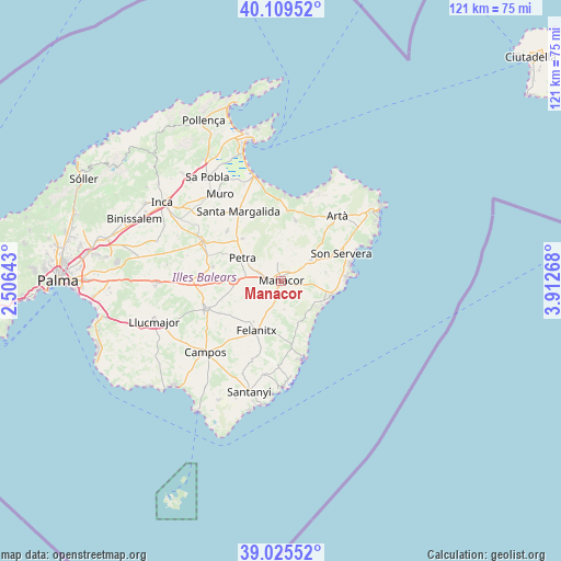
Manacor GPS coordinates[2]
39° 34' 10.704" North, 3° 12' 34.38" East
| Map corner | latitude | longitude |
|---|---|---|
| Upper-left | 40.10952°, | 2.50643° |
| Center: | 39.56964°, | 3.20955° |
| Lower-right: | 39.02552°, | 3.91268° |
| Map W x H: | 120.5×120.5 km | = 74.9×74.9mi |
| max Lat: | 43.74134° ⇑76% North |
| Manacor: | 39.56964° |
| min Lat: | ⇓24% South 27.64134° |
| min Long | Manacor | max Long |
| -18.00367° | 3.20955° | 4.2899° |
| W 99.7%⇐ | ⇒0.3% E |
Elevation
Elevation of Manacor is 91 m = 299 ft, and this is 507 m = 1663 ft below average elevation for this country.
| Max E: |
1682 m = 5518 ft | 88.3% |
| Avg. | 598 m = 1962 ft | |
| Manacor | 91 m = 299 ft | |
Min E: |
0 m = 0 ft | 11.7% |
See also: Manacor elevation on elevation.city.
Geographical zone
Manacor is located in North temperate zone (between Tropic of Cancer and the Arctic Circle). Distance of this Northern Tropic circle is 1793.8 km =1114.6 mi to South.| Distance of | km | miles | from Manacor |
|---|---|---|---|
| North Pole | 5607.3 | 3484.2 | to North |
| Arctic Circle | 3001.4 | 1865 | to North |
| Tropic Cancer | 1793.8 | 1114.6 | to South |
| Equator | 4399.7 | 2733.8 | to South |


Nearby cities:
15 places around Manacor: (largest is in red/bold)
• Ariany
12.4 km =7.7 mi,  316°
316°
• Artà
18.2 km =11.3 mi,  41°
41°
• Calonge
18.8 km =11.7 mi,  181°
181°
• Felanitx
12.3 km =7.6 mi,  205°
205°
• Maria de la Salut
15.6 km =9.7 mi,  311°
311°
• Petra
9.6 km =6 mi,  300°
300°
• Porreres
17.2 km =10.7 mi,  249°
249°
• Porto Cristo
11.1 km =6.9 mi,  107°
107°
• Portocolom
17.6 km =10.9 mi,  166°
166°
• Sant Joan
14.9 km =9.3 mi,  281°
281°
• Sant Llorenç des Cardassar
7.8 km =4.8 mi,  54°
54°
• Santa Margalida
17.3 km =10.7 mi,  327°
327°
• Sineu
18.9 km =11.7 mi, 295°
• Son Servera
14.1 km =8.8 mi,  66°
66°
• Vilafranca de Bonany
10.4 km =6.5 mi,  269°
269°
Sources, notices
• [Note1] Compared only with cities in Spain existing in our database
• [Src1] Map data: © OpenStreetMap contributors (CC-BY-SA)
• [Src2] Other city data from geonames.org with taken over terms of usage.
• [Src3] Geographical zone / Annual Mean Temperature by Robert A. Rohde @ Wikipedia
