Barbate geodata
Barbate (Andalusia) is a populated place; located in Spain in Europe/Madrid (GMT+2) time zone. With population of 22,912 people, there are 405 cities with bigger population in this country. Compared to other cities in Spain, 98.3% of cities are located further ↑North; 85% of cities are located further →East and 96.4% of cities have higher elevation than Barbate. Note1


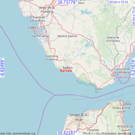
Barbate GPS coordinates[2]
36° 11' 32.532" North, 5° 55' 18.696" West
| Map corner | latitude | longitude |
|---|---|---|
| Upper-left | 36.75776°, | -6.62499° |
| Center: | 36.19237°, | -5.92186° |
| Lower-right: | 35.62287°, | -5.21874° |
| Map W x H: | 126.2×126.2 km | = 78.4×78.4mi |
| max Lat: | 43.74134° ⇑98.3% North |
| Barbate: | 36.19237° |
| min Lat: | ⇓1.7% South 27.64134° |
| min Long | Barbate | max Long |
| -18.00367° | -5.92186° | 4.2899° |
| W 15%⇐ | ⇒85% E |
Elevation
Elevation of Barbate is 18 m = 59 ft, and this is 580 m = 1903 ft below average elevation for this country.
| Max E: |
1682 m = 5518 ft | 96.4% |
| Avg. | 598 m = 1962 ft | |
| Barbate | 18 m = 59 ft | |
Min E: |
0 m = 0 ft | 3.6% |
See also: Spain elevation on elevation.city.
Geographical zone
Barbate is located in North temperate zone (between Tropic of Cancer and the Arctic Circle). Distance of this Northern Tropic circle is 1418.3 km =881.3 mi to South.| Distance of | km | miles | from Barbate |
|---|---|---|---|
| North Pole | 5982.8 | 3717.5 | to North |
| Arctic Circle | 3377 | 2098.4 | to North |
| Tropic Cancer | 1418.3 | 881.3 | to South |
| Equator | 4024.2 | 2500.5 | to South |


Nearby cities:
15 places around Barbate: (largest is in red/bold)
• Alcalá de los Gazules
34.8 km =21.6 mi,  30°
30°
• Algeciras
42.8 km =26.6 mi,  98°
98°
• Benalup-Casas Viejas
19.5 km =12.1 mi, 30°
• Castellar de la Frontera
44.2 km =27.5 mi,  71°
71°
• Chiclana de la Frontera
32.2 km =20 mi,  321°
321°
• Conil de la Frontera
17.7 km =11 mi,  302°
302°
• Los Barrios
38.6 km =24 mi,  91°
91°
• Medina Sidonia
29.4 km =18.3 mi,  359°
359°
• Paterna de Rivera
37 km =23 mi,  7°
7°
• Puerto Real
44.4 km =27.6 mi,  327°
327°
• San Fernando
40.1 km =24.9 mi, 321°
• San José del Valle
47.2 km =29.3 mi, 13°
• Tarifa
34.6 km =21.5 mi,  125°
125°
• Vejer de la Frontera
7.8 km =4.8 mi, 328°
• Zahara de los Atunes
9.2 km =5.7 mi, 132°
Sources, notices
• [Note1] Compared only with cities in Spain existing in our database
• [Src1] Map data: © OpenStreetMap contributors (CC-BY-SA)
• [Src2] Other city data from geonames.org with taken over terms of usage.
• [Src3] Geographical zone / Annual Mean Temperature by Robert A. Rohde @ Wikipedia
