Saceruela geodata
Saceruela (Castille-La Mancha) is a seat of a third-order administrative division; located in Spain in Europe/Madrid (GMT+2) time zone. With population of 686 people, there are 3423 cities with bigger population in this country. Compared to other cities in Spain, 81.6% of cities are located further ↑North; 67.4% of cities are located further →East and 55.3% of cities have higher elevation than Saceruela. Note1
Administrative division(s):
- Level 1: Castille-La Mancha
- Level 2: Provincia de Ciudad Real
- Level 3: Saceruela


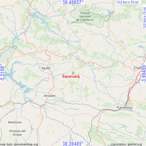
Saceruela GPS coordinates[2]
38° 56' 37.752" North, 4° 36' 27.648" West
| Map corner | latitude | longitude |
|---|---|---|
| Upper-left | 39.48857°, | -5.3108° |
| Center: | 38.94382°, | -4.60768° |
| Lower-right: | 38.39485°, | -3.90455° |
| Map W x H: | 121.6×121.6 km | = 75.6×75.6mi |
| max Lat: | 43.74134° ⇑81.6% North |
| Saceruela: | 38.94382° |
| min Lat: | ⇓18.4% South 27.64134° |
| min Long | Saceruela | max Long |
| -18.00367° | -4.60768° | 4.2899° |
| W 32.6%⇐ | ⇒67.4% E |
Elevation
Elevation of Saceruela is 591 m = 1939 ft, and this is 7 m = 23 ft below average elevation for this country.
| Max E: |
1682 m = 5518 ft | 55.3% |
| Avg. | 598 m = 1962 ft | |
| Saceruela | 591 m = 1939 ft | |
Min E: |
0 m = 0 ft | 44.7% |
See also: Spain elevation on elevation.city.
Geographical zone
Saceruela is located in North temperate zone (between Tropic of Cancer and the Arctic Circle). Distance of this Northern Tropic circle is 1724.2 km =1071.4 mi to South.| Distance of | km | miles | from Saceruela |
|---|---|---|---|
| North Pole | 5676.9 | 3527.5 | to North |
| Arctic Circle | 3071 | 1908.2 | to North |
| Tropic Cancer | 1724.2 | 1071.4 | to South |
| Equator | 4330.1 | 2690.6 | to South |


Nearby cities:
15 places around Saceruela: (largest is in red/bold)
• Abenójar
22.8 km =14.2 mi,  108°
108°
• Agudo
23.2 km =14.4 mi,  280°
280°
• Alamillo
33.5 km =20.8 mi,  208°
208°
• Almadén
27 km =16.8 mi,  225°
225°
• Arroba
24 km =14.9 mi,  13°
13°
• Baterno
26.2 km =16.3 mi,  272°
272°
• Cabezarados
29 km =18 mi, 112°
• Chillón
27.8 km =17.3 mi, 233°
• Fontanarejo
31.7 km =19.7 mi, 14°
• Fuenlabrada de los Montes
35.2 km =21.9 mi,  306°
306°
• Navalpino
31.4 km =19.5 mi,  2°
2°
• Puebla de Don Rodrigo
15.8 km =9.8 mi,  356°
356°
• Tamurejo
28.5 km =17.7 mi, 278°
• Valdemanco del Esteras
19.2 km =11.9 mi, 268°
• Villarta de los Montes
34 km =21.1 mi,  332°
332°
Sources, notices
• [Note1] Compared only with cities in Spain existing in our database
• [Src1] Map data: © OpenStreetMap contributors (CC-BY-SA)
• [Src2] Other city data from geonames.org with taken over terms of usage.
• [Src3] Geographical zone / Annual Mean Temperature by Robert A. Rohde @ Wikipedia
