Baterno geodata
Baterno (Extremadura) is a seat of a third-order administrative division; located in Spain in Europe/Madrid (GMT+2) time zone. With population of 358 people, there are 4286 cities with bigger population in this country. Compared to other cities in Spain, 81.4% of cities are located further ↑North; 71.3% of cities are located further →East and 57.2% of cities have higher elevation than Baterno. Note1


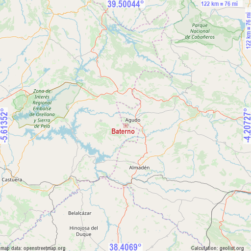
Baterno GPS coordinates[2]
38° 57' 20.808" North, 4° 54' 37.404" West
| Map corner | latitude | longitude |
|---|---|---|
| Upper-left | 39.50044°, | -5.61352° |
| Center: | 38.95578°, | -4.91039° |
| Lower-right: | 38.4069°, | -4.20727° |
| Map W x H: | 121.6×121.6 km | = 75.6×75.6mi |
| max Lat: | 43.74134° ⇑81.4% North |
| Baterno: | 38.95578° |
| min Lat: | ⇓18.6% South 27.64134° |
| min Long | Baterno | max Long |
| -18.00367° | -4.91039° | 4.2899° |
| W 28.7%⇐ | ⇒71.3% E |
Elevation
Elevation of Baterno is 560 m = 1837 ft, and this is 38 m = 125 ft below average elevation for this country.
| Max E: |
1682 m = 5518 ft | 57.2% |
| Avg. | 598 m = 1962 ft | |
| Baterno | 560 m = 1837 ft | |
Min E: |
0 m = 0 ft | 42.8% |
See also: Spain elevation on elevation.city.
Geographical zone
Baterno is located in North temperate zone (between Tropic of Cancer and the Arctic Circle). Distance of this Northern Tropic circle is 1725.6 km =1072.2 mi to South.| Distance of | km | miles | from Baterno |
|---|---|---|---|
| North Pole | 5675.6 | 3526.7 | to North |
| Arctic Circle | 3069.7 | 1907.4 | to North |
| Tropic Cancer | 1725.6 | 1072.2 | to South |
| Equator | 4331.5 | 2691.5 | to South |


Nearby cities:
15 places around Baterno: (largest is in red/bold)
• Agudo
4.4 km =2.7 mi,  49°
49°
• Almadén
21.2 km =13.2 mi,  161°
161°
• Capilla
21.3 km =13.2 mi,  224°
224°
• Chillón
18.2 km =11.3 mi,  167°
167°
• Fuenlabrada de los Montes
19.8 km =12.3 mi,  353°
353°
• Garbayuela
12.9 km =8 mi,  323°
323°
• Garlitos
14.5 km =9 mi,  234°
234°
• Guadalmez
26 km =16.2 mi,  191°
191°
• Herrera del Duque
26.6 km =16.5 mi,  332°
332°
• Peñalsordo
23.2 km =14.4 mi, 229°
• Puebla de Don Rodrigo
29 km =18 mi,  60°
60°
• Saceruela
26.2 km =16.3 mi,  92°
92°
• Siruela
12.3 km =7.6 mi,  281°
281°
• Tamurejo
3.6 km =2.2 mi, 327°
• Valdemanco del Esteras
7.3 km =4.5 mi,  105°
105°
Sources, notices
• [Note1] Compared only with cities in Spain existing in our database
• [Src1] Map data: © OpenStreetMap contributors (CC-BY-SA)
• [Src2] Other city data from geonames.org with taken over terms of usage.
• [Src3] Geographical zone / Annual Mean Temperature by Robert A. Rohde @ Wikipedia
