Alamillo geodata
Alamillo (Castille-La Mancha) is a seat of a third-order administrative division; located in Spain in Europe/Madrid (GMT+2) time zone. In our database, there are 6762 cities with bigger population. Compared to other cities in Spain, 84.4% of cities are located further ↑North; 69.6% of cities are located further →East and 65.7% of cities have higher elevation than Alamillo. Note1
Administrative division(s):
- Level 1: Castille-La Mancha
- Level 2: Provincia de Ciudad Real
- Level 3: Alamillo


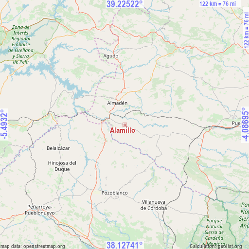
Alamillo GPS coordinates[2]
38° 40' 42.312" North, 4° 47' 24.288" West
| Map corner | latitude | longitude |
|---|---|---|
| Upper-left | 39.22522°, | -5.4932° |
| Center: | 38.67842°, | -4.79008° |
| Lower-right: | 38.12741°, | -4.08695° |
| Map W x H: | 122.1×122.1 km | = 75.9×75.9mi |
| max Lat: | 43.74134° ⇑84.4% North |
| Alamillo: | 38.67842° |
| min Lat: | ⇓15.6% South 27.64134° |
| min Long | Alamillo | max Long |
| -18.00367° | -4.79008° | 4.2899° |
| W 30.4%⇐ | ⇒69.6% E |
Elevation
Elevation of Alamillo is 450 m = 1476 ft, and this is 148 m = 486 ft below average elevation for this country.
| Max E: |
1682 m = 5518 ft | 65.7% |
| Avg. | 598 m = 1962 ft | |
| Alamillo | 450 m = 1476 ft | |
Min E: |
0 m = 0 ft | 34.3% |
See also: Spain elevation on elevation.city.
Geographical zone
Alamillo is located in North temperate zone (between Tropic of Cancer and the Arctic Circle). Distance of this Northern Tropic circle is 1694.7 km =1053 mi to South.| Distance of | km | miles | from Alamillo |
|---|---|---|---|
| North Pole | 5706.4 | 3545.8 | to North |
| Arctic Circle | 3100.5 | 1926.6 | to North |
| Tropic Cancer | 1694.7 | 1053 | to South |
| Equator | 4300.6 | 2672.3 | to South |


Nearby cities:
15 places around Alamillo: (largest is in red/bold)
• Almadén
11.4 km =7.1 mi,  341°
341°
• Añora
30.6 km =19 mi,  198°
198°
• Baterno
32.6 km =20.3 mi, 341°
• Capilla
30 km =18.6 mi,  301°
301°
• Chillón
14.6 km =9.1 mi,  333°
333°
• Dos Torres
27.1 km =16.8 mi, 200°
• El Viso
25.8 km =16 mi,  212°
212°
• Garlitos
31.6 km =19.6 mi,  315°
315°
• Guadalmez
16.6 km =10.3 mi,  288°
288°
• Pedroche
27.9 km =17.3 mi,  175°
175°
• Peñalsordo
32.2 km =20 mi, 299°
• Santa Eufemia
12.9 km =8 mi,  227°
227°
• Torrecampo
25.9 km =16.1 mi,  155°
155°
• Valdemanco del Esteras
29.1 km =18.1 mi,  353°
353°
• Villaralto
30.5 km =19 mi, 213°
Sources, notices
• [Note1] Compared only with cities in Spain existing in our database
• [Src1] Map data: © OpenStreetMap contributors (CC-BY-SA)
• [Src2] Other city data from geonames.org with taken over terms of usage.
• [Src3] Geographical zone / Annual Mean Temperature by Robert A. Rohde @ Wikipedia
