Almadén geodata
Almadén (Castille-La Mancha) is a seat of a third-order administrative division; located in Spain in Europe/Madrid (GMT+2) time zone. In our database, there are 6762 cities with bigger population. Compared to other cities in Spain, 83.5% of cities are located further ↑North; 70.1% of cities are located further →East and 56.9% of cities have higher elevation than Almadén. Note1
Administrative division(s):
- Level 1: Castille-La Mancha
- Level 2: Provincia de Ciudad Real
- Level 3: Almadén


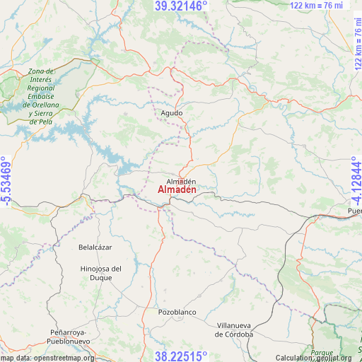
Almadén GPS coordinates[2]
38° 46' 31.476" North, 4° 49' 53.616" West
| Map corner | latitude | longitude |
|---|---|---|
| Upper-left | 39.32146°, | -5.53469° |
| Center: | 38.77541°, | -4.83156° |
| Lower-right: | 38.22515°, | -4.12844° |
| Map W x H: | 121.9×121.9 km | = 75.7×75.7mi |
| max Lat: | 43.74134° ⇑83.5% North |
| Almadén: | 38.77541° |
| min Lat: | ⇓16.5% South 27.64134° |
| min Long | Almadén | max Long |
| -18.00367° | -4.83156° | 4.2899° |
| W 29.9%⇐ | ⇒70.1% E |
Elevation
Elevation of Almadén is 567 m = 1860 ft, and this is 31 m = 102 ft below average elevation for this country.
| Max E: |
1682 m = 5518 ft | 56.9% |
| Avg. | 598 m = 1962 ft | |
| Almadén | 567 m = 1860 ft | |
Min E: |
0 m = 0 ft | 43.1% |
See also: Spain elevation on elevation.city.
Geographical zone
Almadén is located in North temperate zone (between Tropic of Cancer and the Arctic Circle). Distance of this Northern Tropic circle is 1705.5 km =1059.7 mi to South.| Distance of | km | miles | from Almadén |
|---|---|---|---|
| North Pole | 5695.6 | 3539.1 | to North |
| Arctic Circle | 3089.8 | 1919.9 | to North |
| Tropic Cancer | 1705.5 | 1059.7 | to South |
| Equator | 4311.4 | 2679 | to South |


Nearby cities:
15 places around Almadén: (largest is in red/bold)
• Agudo
23.2 km =14.4 mi,  351°
351°
• Alamillo
11.4 km =7.1 mi,  161°
161°
• Baterno
21.2 km =13.2 mi,  341°
341°
• Capilla
22.5 km =14 mi,  282°
282°
• Chillón
3.8 km =2.4 mi,  307°
307°
• El Viso
34.1 km =21.2 mi,  197°
197°
• Garbayuela
33.7 km =20.9 mi,  334°
334°
• Garlitos
22 km =13.7 mi,  301°
301°
• Guadalmez
13.3 km =8.3 mi,  245°
245°
• Peñalsordo
25 km =15.5 mi, 281°
• Saceruela
27 km =16.8 mi,  45°
45°
• Santa Eufemia
20.4 km =12.7 mi, 196°
• Siruela
29.3 km =18.2 mi,  319°
319°
• Tamurejo
24.7 km =15.3 mi, 339°
• Valdemanco del Esteras
18.1 km =11.2 mi,  0°
0°
Sources, notices
• [Note1] Compared only with cities in Spain existing in our database
• [Src1] Map data: © OpenStreetMap contributors (CC-BY-SA)
• [Src2] Other city data from geonames.org with taken over terms of usage.
• [Src3] Geographical zone / Annual Mean Temperature by Robert A. Rohde @ Wikipedia
