Lillo geodata
Lillo (Castille-La Mancha) is a seat of a third-order administrative division; located in Spain in Europe/Madrid (GMT+2) time zone. With population of 2,615 people, there are 1854 cities with bigger population in this country. Compared to other cities in Spain, 73.9% of cities are located further ↑North; 50.3% of cities are located further ←West and 52.7% of cities have lower elevation than Lillo. Note1


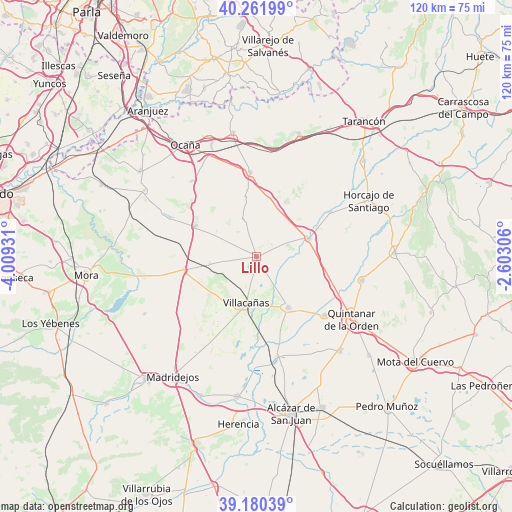
Lillo GPS coordinates[2]
39° 43' 23.916" North, 3° 18' 22.248" West
| Map corner | latitude | longitude |
|---|---|---|
| Upper-left | 40.26199°, | -4.00931° |
| Center: | 39.72331°, | -3.30618° |
| Lower-right: | 39.18039°, | -2.60306° |
| Map W x H: | 120.3×120.3 km | = 74.8×74.8mi |
| max Lat: | 43.74134° ⇑73.9% North |
| Lillo: | 39.72331° |
| min Lat: | ⇓26.1% South 27.64134° |
| min Long | Lillo | max Long |
| -18.00367° | -3.30618° | 4.2899° |
| W 50.3%⇐ | ⇒49.7% E |
Elevation
Elevation of Lillo is 687 m = 2254 ft, and this is 89 m = 292 ft above average elevation for this country.
| Max E: |
1682 m = 5518 ft | 47.3% |
| Lillo | 687 m 2254 ft | |
| Avg. | 598 m = 1962 ft | |
Min E: |
0 m = 0 ft | 52.7% |
See also: Spain elevation on elevation.city.
Geographical zone
Lillo is located in North temperate zone (between Tropic of Cancer and the Arctic Circle). Distance of this Northern Tropic circle is 1810.9 km =1125.2 mi to South.| Distance of | km | miles | from Lillo |
|---|---|---|---|
| North Pole | 5590.2 | 3473.6 | to North |
| Arctic Circle | 2984.4 | 1854.4 | to North |
| Tropic Cancer | 1810.9 | 1125.2 | to South |
| Equator | 4416.8 | 2744.5 | to South |


Nearby cities:
15 places around Lillo: (largest is in red/bold)
• Cabañas de Yepes
27 km =16.8 mi,  313°
313°
• Cabezamesada
20.3 km =12.6 mi,  59°
59°
• Corral de Almaguer
12.8 km =8 mi,  71°
71°
• Dosbarrios
23.3 km =14.5 mi,  319°
319°
• Horcajo de Santiago
29.5 km =18.3 mi, 63°
• La Guardia
16.2 km =10.1 mi,  296°
296°
• La Puebla de Almoradiel
21.3 km =13.2 mi,  130°
130°
• Quero
24.1 km =15 mi,  167°
167°
• Quintanar de la Orden
26.8 km =16.7 mi,  122°
122°
• Romeral
11.1 km =6.9 mi,  260°
260°
• Tembleque
17.2 km =10.7 mi, 259°
• Villa de Don Fadrique
14.2 km =8.8 mi,  148°
148°
• Villacañas
11.4 km =7.1 mi,  193°
193°
• Villanueva de Alcardete
25.6 km =15.9 mi,  102°
102°
• Villatobas
19.9 km =12.4 mi,  355°
355°
Sources, notices
• [Note1] Compared only with cities in Spain existing in our database
• [Src1] Map data: © OpenStreetMap contributors (CC-BY-SA)
• [Src2] Other city data from geonames.org with taken over terms of usage.
• [Src3] Geographical zone / Annual Mean Temperature by Robert A. Rohde @ Wikipedia
