Romeral geodata
Romeral (Castille-La Mancha) is a populated place; located in Spain in Europe/Madrid (GMT+2) time zone. With population of 847 people, there are 3135 cities with bigger population in this country. Compared to other cities in Spain, 74.3% of cities are located further ↑North; 51.2% of cities are located further →East and 50.5% of cities have lower elevation than Romeral. Note1
Administrative division(s):
- Level 1: Castille-La Mancha
- Level 2: Province of Toledo
- Level 3: Tembleque


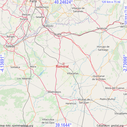
Romeral GPS coordinates[2]
39° 42' 26.784" North, 3° 26' 1.644" West
| Map corner | latitude | longitude |
|---|---|---|
| Upper-left | 40.24624°, | -4.13691° |
| Center: | 39.70744°, | -3.43379° |
| Lower-right: | 39.1644°, | -2.73066° |
| Map W x H: | 120.3×120.3 km | = 74.8×74.8mi |
| max Lat: | 43.74134° ⇑74.3% North |
| Romeral: | 39.70744° |
| min Lat: | ⇓25.7% South 27.64134° |
| min Long | Romeral | max Long |
| -18.00367° | -3.43379° | 4.2899° |
| W 48.8%⇐ | ⇒51.2% E |
Elevation
Elevation of Romeral is 664 m = 2178 ft, and this is 66 m = 217 ft above average elevation for this country.
| Max E: |
1682 m = 5518 ft | 49.5% |
| Romeral | 664 m 2178 ft | |
| Avg. | 598 m = 1962 ft | |
Min E: |
0 m = 0 ft | 50.5% |
See also: Spain elevation on elevation.city.
Geographical zone
Romeral is located in North temperate zone (between Tropic of Cancer and the Arctic Circle). Distance of this Northern Tropic circle is 1809.1 km =1124.1 mi to South.| Distance of | km | miles | from Romeral |
|---|---|---|---|
| North Pole | 5592 | 3474.7 | to North |
| Arctic Circle | 2986.1 | 1855.5 | to North |
| Tropic Cancer | 1809.1 | 1124.1 | to South |
| Equator | 4415.1 | 2743.4 | to South |


Nearby cities:
15 places around Romeral: (largest is in red/bold)
• Cabañas de Yepes
22.1 km =13.7 mi,  336°
336°
• Corral de Almaguer
23.8 km =14.8 mi,  75°
75°
• Dosbarrios
19.9 km =12.4 mi,  347°
347°
• Huerta de Valdecarábanos
23.1 km =14.4 mi,  318°
318°
• La Guardia
9.7 km =6 mi, 338°
• Lillo
11.1 km =6.9 mi, 80°
• Madridejos
27.9 km =17.3 mi,  197°
197°
• Quero
27 km =16.8 mi,  143°
143°
• Tembleque
6.2 km =3.9 mi,  257°
257°
• Turleque
19.4 km =12.1 mi,  232°
232°
• Villa de Don Fadrique
21 km =13 mi,  119°
119°
• Villacañas
12.4 km =7.7 mi, 138°
• Villanueva de Bogas
19.2 km =11.9 mi,  275°
275°
• Villatobas
23.6 km =14.7 mi,  23°
23°
• Yepes
27.1 km =16.8 mi, 322°
Sources, notices
• [Note1] Compared only with cities in Spain existing in our database
• [Src1] Map data: © OpenStreetMap contributors (CC-BY-SA)
• [Src2] Other city data from geonames.org with taken over terms of usage.
• [Src3] Geographical zone / Annual Mean Temperature by Robert A. Rohde @ Wikipedia
