Puebla de Alcocer geodata
Puebla de Alcocer (Extremadura) is a populated place; located in Spain in Europe/Madrid (GMT+2) time zone. With population of 1,270 people, there are 2667 cities with bigger population in this country. Compared to other cities in Spain, 81% of cities are located further ↑North; 75.8% of cities are located further →East and 61.8% of cities have higher elevation than Puebla de Alcocer. Note1
Administrative division(s):
- Level 1: Extremadura
- Level 2: Provincia de Badajoz
- Level 3: Esparragosa de Lares


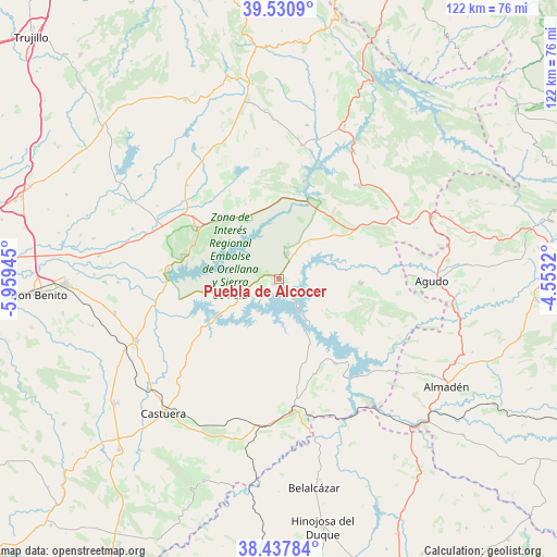
Puebla de Alcocer GPS coordinates[2]
38° 59' 11.328" North, 5° 15' 22.788" West
| Map corner | latitude | longitude |
|---|---|---|
| Upper-left | 39.5309°, | -5.95945° |
| Center: | 38.98648°, | -5.25633° |
| Lower-right: | 38.43784°, | -4.5532° |
| Map W x H: | 121.5×121.5 km | = 75.5×75.5mi |
| max Lat: | 43.74134° ⇑81% North |
| Puebla de Alcocer: | 38.98648° |
| min Lat: | ⇓19% South 27.64134° |
| min Long | Puebla de Alcoc | max Long |
| -18.00367° | -5.25633° | 4.2899° |
| W 24.2%⇐ | ⇒75.8% E |
Elevation
Elevation of Puebla de Alcocer is 502 m = 1647 ft, and this is 96 m = 315 ft below average elevation for this country.
| Max E: |
1682 m = 5518 ft | 61.8% |
| Avg. | 598 m = 1962 ft | |
| Puebla de Alcocer | 502 m = 1647 ft | |
Min E: |
0 m = 0 ft | 38.2% |
See also: Spain elevation on elevation.city.
Geographical zone
Puebla de Alcocer is located in North temperate zone (between Tropic of Cancer and the Arctic Circle). Distance of this Northern Tropic circle is 1729 km =1074.4 mi to South.| Distance of | km | miles | from Puebla de Alcocer |
|---|---|---|---|
| North Pole | 5672.2 | 3524.5 | to North |
| Arctic Circle | 3066.3 | 1905.3 | to North |
| Tropic Cancer | 1729 | 1074.4 | to South |
| Equator | 4334.9 | 2693.6 | to South |


Nearby cities:
15 places around Puebla de Alcocer: (largest is in red/bold)
• Acedera
29.2 km =18.1 mi,  290°
290°
• Cabeza del Buey
29.6 km =18.4 mi,  173°
173°
• Capilla
23.7 km =14.7 mi,  141°
141°
• Casas de Don Pedro
15 km =9.3 mi,  334°
334°
• Esparragosa de Lares
1.7 km =1.1 mi,  222°
222°
• Garbayuela
23.3 km =14.5 mi,  72°
72°
• Garlitos
21.6 km =13.4 mi,  123°
123°
• Herrera del Duque
26.9 km =16.7 mi,  41°
41°
• Navalvillar de Pela
21.9 km =13.6 mi,  303°
303°
• Orellana la Vieja
24.1 km =15 mi,  275°
275°
• Peñalsordo
22.2 km =13.8 mi,  146°
146°
• Siruela
17.9 km =11.1 mi,  93°
93°
• Talarrubias
5.9 km =3.7 mi,  18°
18°
• Tamurejo
27.9 km =17.3 mi, 90°
• Valdecaballeros
29.1 km =18.1 mi,  11°
11°
Sources, notices
• [Note1] Compared only with cities in Spain existing in our database
• [Src1] Map data: © OpenStreetMap contributors (CC-BY-SA)
• [Src2] Other city data from geonames.org with taken over terms of usage.
• [Src3] Geographical zone / Annual Mean Temperature by Robert A. Rohde @ Wikipedia
