Capilla geodata
Capilla (Extremadura) is a seat of a third-order administrative division; located in Spain in Europe/Madrid (GMT+2) time zone. With population of 192 people, there are 5092 cities with bigger population in this country. Compared to other cities in Spain, 83.1% of cities are located further ↑North; 73.6% of cities are located further →East and 63% of cities have higher elevation than Capilla. Note1


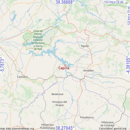
Capilla GPS coordinates[2]
38° 49' 13.332" North, 5° 5' 3.012" West
| Map corner | latitude | longitude |
|---|---|---|
| Upper-left | 39.36608°, | -5.7873° |
| Center: | 38.82037°, | -5.08417° |
| Lower-right: | 38.27045°, | -4.38105° |
| Map W x H: | 121.8×121.8 km | = 75.7×75.7mi |
| max Lat: | 43.74134° ⇑83.1% North |
| Capilla: | 38.82037° |
| min Lat: | ⇓16.9% South 27.64134° |
| min Long | Capilla | max Long |
| -18.00367° | -5.08417° | 4.2899° |
| W 26.4%⇐ | ⇒73.6% E |
Elevation
Elevation of Capilla is 487 m = 1598 ft, and this is 111 m = 364 ft below average elevation for this country.
| Max E: |
1682 m = 5518 ft | 63% |
| Avg. | 598 m = 1962 ft | |
| Capilla | 487 m = 1598 ft | |
Min E: |
0 m = 0 ft | 37% |
See also: Spain elevation on elevation.city.
Geographical zone
Capilla is located in North temperate zone (between Tropic of Cancer and the Arctic Circle). Distance of this Northern Tropic circle is 1710.5 km =1062.9 mi to South.| Distance of | km | miles | from Capilla |
|---|---|---|---|
| North Pole | 5690.6 | 3536 | to North |
| Arctic Circle | 3084.8 | 1916.8 | to North |
| Tropic Cancer | 1710.5 | 1062.9 | to South |
| Equator | 4316.4 | 2682.1 | to South |


Nearby cities:
15 places around Capilla: (largest is in red/bold)
• Agudo
25.7 km =16 mi,  45°
45°
• Almadén
22.5 km =14 mi,  102°
102°
• Baterno
21.3 km =13.2 mi,  44°
44°
• Cabeza del Buey
16 km =9.9 mi,  227°
227°
• Chillón
19.1 km =11.9 mi, 98°
• Esparragosa de Lares
23.5 km =14.6 mi,  316°
316°
• Garbayuela
26.5 km =16.5 mi,  16°
16°
• Garlitos
7.4 km =4.6 mi,  25°
25°
• Guadalmez
14.3 km =8.9 mi,  136°
136°
• Peñalsordo
2.6 km =1.6 mi,  269°
269°
• Puebla de Alcocer
23.7 km =14.7 mi, 321°
• Siruela
17.7 km =11 mi,  9°
9°
• Talarrubias
27.4 km =17 mi,  331°
331°
• Tamurejo
22.3 km =13.9 mi, 35°
• Valdemanco del Esteras
25.7 km =16 mi,  59°
59°
Sources, notices
• [Note1] Compared only with cities in Spain existing in our database
• [Src1] Map data: © OpenStreetMap contributors (CC-BY-SA)
• [Src2] Other city data from geonames.org with taken over terms of usage.
• [Src3] Geographical zone / Annual Mean Temperature by Robert A. Rohde @ Wikipedia
