Garlitos geodata
Garlitos (Extremadura) is a seat of a third-order administrative division; located in Spain in Europe/Madrid (GMT+2) time zone. With population of 721 people, there are 3367 cities with bigger population in this country. Compared to other cities in Spain, 82.4% of cities are located further ↑North; 73.1% of cities are located further →East and 59.1% of cities have higher elevation than Garlitos. Note1


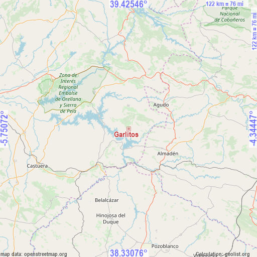
Garlitos GPS coordinates[2]
38° 52' 48.792" North, 5° 2' 51.324" West
| Map corner | latitude | longitude |
|---|---|---|
| Upper-left | 39.42546°, | -5.75072° |
| Center: | 38.88022°, | -5.04759° |
| Lower-right: | 38.33076°, | -4.34447° |
| Map W x H: | 121.7×121.7 km | = 75.6×75.6mi |
| max Lat: | 43.74134° ⇑82.4% North |
| Garlitos: | 38.88022° |
| min Lat: | ⇓17.6% South 27.64134° |
| min Long | Garlitos | max Long |
| -18.00367° | -5.04759° | 4.2899° |
| W 26.9%⇐ | ⇒73.1% E |
Elevation
Elevation of Garlitos is 539 m = 1768 ft, and this is 59 m = 194 ft below average elevation for this country.
| Max E: |
1682 m = 5518 ft | 59.1% |
| Avg. | 598 m = 1962 ft | |
| Garlitos | 539 m = 1768 ft | |
Min E: |
0 m = 0 ft | 40.9% |
See also: Spain elevation on elevation.city.
Geographical zone
Garlitos is located in North temperate zone (between Tropic of Cancer and the Arctic Circle). Distance of this Northern Tropic circle is 1717.2 km =1067 mi to South.| Distance of | km | miles | from Garlitos |
|---|---|---|---|
| North Pole | 5684 | 3531.9 | to North |
| Arctic Circle | 3078.1 | 1912.6 | to North |
| Tropic Cancer | 1717.2 | 1067 | to South |
| Equator | 4323.1 | 2686.2 | to South |


Nearby cities:
15 places around Garlitos: (largest is in red/bold)
• Agudo
19 km =11.8 mi,  53°
53°
• Almadén
22 km =13.7 mi,  121°
121°
• Baterno
14.5 km =9 mi, 54°
• Cabeza del Buey
23 km =14.3 mi,  220°
220°
• Capilla
7.4 km =4.6 mi,  205°
205°
• Chillón
18.3 km =11.4 mi, 120°
• Esparragosa de Lares
21.9 km =13.6 mi,  298°
298°
• Garbayuela
19.3 km =12 mi,  12°
12°
• Guadalmez
18.3 km =11.4 mi,  158°
158°
• Peñalsordo
8.8 km =5.5 mi, 220°
• Puebla de Alcocer
21.6 km =13.4 mi, 303°
• Siruela
10.8 km =6.7 mi,  359°
359°
• Talarrubias
23.8 km =14.8 mi,  317°
317°
• Tamurejo
15.1 km =9.4 mi,  40°
40°
• Valdemanco del Esteras
20 km =12.4 mi,  71°
71°
Sources, notices
• [Note1] Compared only with cities in Spain existing in our database
• [Src1] Map data: © OpenStreetMap contributors (CC-BY-SA)
• [Src2] Other city data from geonames.org with taken over terms of usage.
• [Src3] Geographical zone / Annual Mean Temperature by Robert A. Rohde @ Wikipedia
