Orellana la Vieja geodata
Orellana la Vieja (Extremadura) is a seat of a third-order administrative division; located in Spain in Europe/Madrid (GMT+2) time zone. With population of 3,193 people, there are 1663 cities with bigger population in this country. Compared to other cities in Spain, 80.9% of cities are located further ↑North; 79.1% of cities are located further →East and 71.5% of cities have higher elevation than Orellana la Vieja. Note1
Administrative division(s):
- Level 1: Extremadura
- Level 2: Provincia de Badajoz
- Level 3: Orellana la Vieja


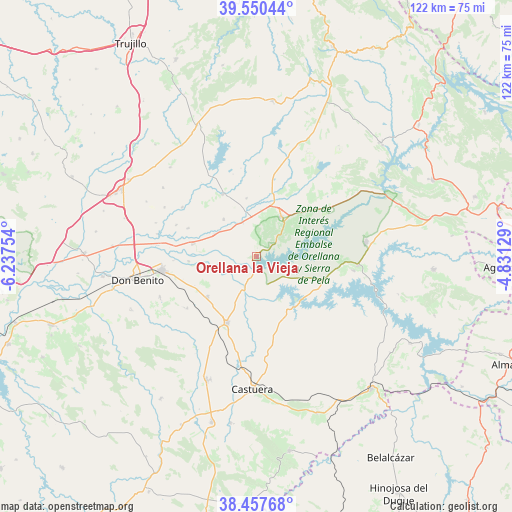
Orellana la Vieja GPS coordinates[2]
39° 0' 22.212" North, 5° 32' 3.876" West
| Map corner | latitude | longitude |
|---|---|---|
| Upper-left | 39.55044°, | -6.23754° |
| Center: | 39.00617°, | -5.53441° |
| Lower-right: | 38.45768°, | -4.83129° |
| Map W x H: | 121.5×121.5 km | = 75.5×75.5mi |
| max Lat: | 43.74134° ⇑80.9% North |
| Orellana la Vieja: | 39.00617° |
| min Lat: | ⇓19.1% South 27.64134° |
| min Long | Orellana la Vie | max Long |
| -18.00367° | -5.53441° | 4.2899° |
| W 20.9%⇐ | ⇒79.1% E |
Elevation
Elevation of Orellana la Vieja is 356 m = 1168 ft, and this is 242 m = 794 ft below average elevation for this country.
| Max E: |
1682 m = 5518 ft | 71.5% |
| Avg. | 598 m = 1962 ft | |
| Orellana la Vieja | 356 m = 1168 ft | |
Min E: |
0 m = 0 ft | 28.5% |
See also: Spain elevation on elevation.city.
Geographical zone
Orellana la Vieja is located in North temperate zone (between Tropic of Cancer and the Arctic Circle). Distance of this Northern Tropic circle is 1731.2 km =1075.7 mi to South.| Distance of | km | miles | from Orellana la Vieja |
|---|---|---|---|
| North Pole | 5670 | 3523.2 | to North |
| Arctic Circle | 3064.1 | 1903.9 | to North |
| Tropic Cancer | 1731.2 | 1075.7 | to South |
| Equator | 4337.1 | 2694.9 | to South |


Nearby cities:
15 places around Orellana la Vieja: (largest is in red/bold)
• Acedera
8.6 km =5.3 mi,  336°
336°
• Campanario
17.3 km =10.7 mi,  204°
204°
• Casas de Don Pedro
20.9 km =13 mi,  57°
57°
• Don Benito
28.8 km =17.9 mi,  258°
258°
• Esparragosa de Lares
23.1 km =14.4 mi,  98°
98°
• La Coronada
15.1 km =9.4 mi,  230°
230°
• La Haba
24.9 km =15.5 mi,  247°
247°
• Madrigalejo
16.8 km =10.4 mi,  331°
331°
• Magacela
21.2 km =13.2 mi, 234°
• Navalvillar de Pela
11.4 km =7.1 mi,  30°
30°
• Puebla de Alcocer
24.1 km =15 mi, 95°
• Rena
24.2 km =15 mi,  282°
282°
• Talarrubias
26.2 km =16.3 mi,  82°
82°
• Villanueva de la Serena
23 km =14.3 mi, 261°
• Villar de Rena
25.1 km =15.6 mi,  288°
288°
Sources, notices
• [Note1] Compared only with cities in Spain existing in our database
• [Src1] Map data: © OpenStreetMap contributors (CC-BY-SA)
• [Src2] Other city data from geonames.org with taken over terms of usage.
• [Src3] Geographical zone / Annual Mean Temperature by Robert A. Rohde @ Wikipedia
