Huélago geodata
Huélago (Andalusia) is a seat of a third-order administrative division; located in Spain in Europe/Madrid (GMT+2) time zone. With population of 459 people, there are 3984 cities with bigger population in this country. Compared to other cities in Spain, 91.7% of cities are located further ↑North; 50.9% of cities are located further ←West and 82.3% of cities have lower elevation than Huélago. Note1


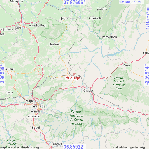
Huélago GPS coordinates[2]
37° 25' 10.992" North, 3° 15' 44.136" West
| Map corner | latitude | longitude |
|---|---|---|
| Upper-left | 37.97606°, | -3.96539° |
| Center: | 37.41972°, | -3.26226° |
| Lower-right: | 36.85922°, | -2.55914° |
| Map W x H: | 124.2×124.2 km | = 77.2×77.2mi |
| max Lat: | 43.74134° ⇑91.7% North |
| Huélago: | 37.41972° |
| min Lat: | ⇓8.3% South 27.64134° |
| min Long | Huélago | max Long |
| -18.00367° | -3.26226° | 4.2899° |
| W 50.9%⇐ | ⇒49.1% E |
Elevation
Elevation of Huélago is 920 m = 3018 ft, and this is 322 m = 1056 ft above average elevation for this country.
| Max E: |
1682 m = 5518 ft | 17.7% |
| Huélago | 920 m 3018 ft | |
| Avg. | 598 m = 1962 ft | |
Min E: |
0 m = 0 ft | 82.3% |
See also: Spain elevation on elevation.city.
Geographical zone
Huélago is located in North temperate zone (between Tropic of Cancer and the Arctic Circle). Distance of this Northern Tropic circle is 1554.8 km =966.1 mi to South.| Distance of | km | miles | from Huélago |
|---|---|---|---|
| North Pole | 5846.4 | 3632.8 | to North |
| Arctic Circle | 3240.5 | 2013.6 | to North |
| Tropic Cancer | 1554.8 | 966.1 | to South |
| Equator | 4160.7 | 2585.3 | to South |


Nearby cities:
15 places around Huélago: (largest is in red/bold)
• Alamedilla
18.2 km =11.3 mi,  5°
5°
• Beas de Guadix
16.5 km =10.3 mi,  162°
162°
• Benalúa de Guadix
11.5 km =7.1 mi,  130°
130°
• Darro
8.3 km =5.2 mi,  200°
200°
• Diezma
12.7 km =7.9 mi,  209°
209°
• Fonelas
8.1 km =5 mi,  97°
97°
• Gobernador
8.3 km =5.2 mi,  321°
321°
• Guadahortuna
19.4 km =12.1 mi, 321°
• Guadix
17.2 km =10.7 mi,  140°
140°
• Marchal
14.7 km =9.1 mi, 159°
• Pedro Martínez
9.6 km =6 mi,  16°
16°
• Piñar
15.8 km =9.8 mi,  280°
280°
• Polícar
18.2 km =11.3 mi,  172°
172°
• Purullena
13 km =8.1 mi,  150°
150°
• Torre-Cardela
12.6 km =7.8 mi, 318°
Sources, notices
• [Note1] Compared only with cities in Spain existing in our database
• [Src1] Map data: © OpenStreetMap contributors (CC-BY-SA)
• [Src2] Other city data from geonames.org with taken over terms of usage.
• [Src3] Geographical zone / Annual Mean Temperature by Robert A. Rohde @ Wikipedia
