Guadahortuna geodata
Guadahortuna (Andalusia) is a populated place; located in Spain in Europe/Madrid (GMT+2) time zone. With population of 2,004 people, there are 2164 cities with bigger population in this country. Compared to other cities in Spain, 91% of cities are located further ↑North; 50.7% of cities are located further →East and 86% of cities have lower elevation than Guadahortuna. Note1


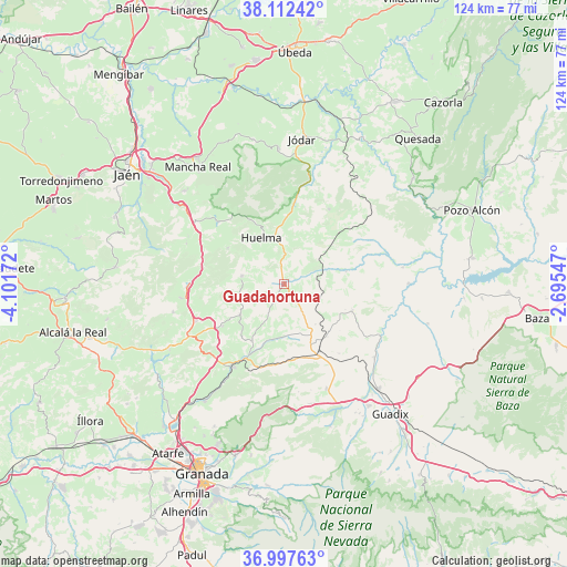
Guadahortuna GPS coordinates[2]
37° 33' 25.596" North, 3° 23' 54.924" West
| Map corner | latitude | longitude |
|---|---|---|
| Upper-left | 38.11242°, | -4.10172° |
| Center: | 37.55711°, | -3.39859° |
| Lower-right: | 36.99763°, | -2.69547° |
| Map W x H: | 124×124 km | = 77.1×77.1mi |
| max Lat: | 43.74134° ⇑91% North |
| Guadahortuna: | 37.55711° |
| min Lat: | ⇓9% South 27.64134° |
| min Long | Guadahortuna | max Long |
| -18.00367° | -3.39859° | 4.2899° |
| W 49.3%⇐ | ⇒50.7% E |
Elevation
Elevation of Guadahortuna is 964 m = 3163 ft, and this is 366 m = 1201 ft above average elevation for this country.
| Max E: |
1682 m = 5518 ft | 14% |
| Guadahortuna | 964 m 3163 ft | |
| Avg. | 598 m = 1962 ft | |
Min E: |
0 m = 0 ft | 86% |
See also: Spain elevation on elevation.city.
Geographical zone
Guadahortuna is located in North temperate zone (between Tropic of Cancer and the Arctic Circle). Distance of this Northern Tropic circle is 1570 km =975.6 mi to South.| Distance of | km | miles | from Guadahortuna |
|---|---|---|---|
| North Pole | 5831.1 | 3623.3 | to North |
| Arctic Circle | 3225.2 | 2004 | to North |
| Tropic Cancer | 1570 | 975.6 | to South |
| Equator | 4176 | 2594.8 | to South |


Nearby cities:
15 places around Guadahortuna: (largest is in red/bold)
• Alamedilla
14 km =8.7 mi,  78°
78°
• Bélmez de la Moraleda
18.6 km =11.6 mi,  4°
4°
• Cabra del Santo Cristo
19 km =11.8 mi,  30°
30°
• Cambil
20 km =12.4 mi,  312°
312°
• Campillo de Arenas
20.9 km =13 mi,  269°
269°
• Campotéjar
21 km =13 mi,  246°
246°
• Dehesas Viejas
16.4 km =10.2 mi,  235°
235°
• Domingo Pérez
11.9 km =7.4 mi, 235°
• Gobernador
11.1 km =6.9 mi,  142°
142°
• Huelma
11.4 km =7.1 mi,  331°
331°
• Huélago
19.4 km =12.1 mi, 141°
• Montejicar
9.6 km =6 mi,  280°
280°
• Pedro Martínez
15.9 km =9.9 mi,  112°
112°
• Piñar
13 km =8.1 mi,  195°
195°
• Torre-Cardela
6.9 km =4.3 mi,  147°
147°
Sources, notices
• [Note1] Compared only with cities in Spain existing in our database
• [Src1] Map data: © OpenStreetMap contributors (CC-BY-SA)
• [Src2] Other city data from geonames.org with taken over terms of usage.
• [Src3] Geographical zone / Annual Mean Temperature by Robert A. Rohde @ Wikipedia
