Gobernador geodata
Gobernador (Andalusia) is a seat of a third-order administrative division; located in Spain in Europe/Madrid (GMT+2) time zone. With population of 313 people, there are 4452 cities with bigger population in this country. Compared to other cities in Spain, 91.4% of cities are located further ↑North; 50.2% of cities are located further ←West and 90.4% of cities have lower elevation than Gobernador. Note1


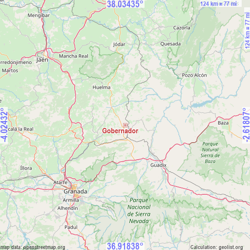
Gobernador GPS coordinates[2]
37° 28' 42.42" North, 3° 19' 16.284" West
| Map corner | latitude | longitude |
|---|---|---|
| Upper-left | 38.03435°, | -4.02432° |
| Center: | 37.47845°, | -3.32119° |
| Lower-right: | 36.91838°, | -2.61807° |
| Map W x H: | 124.1×124.1 km | = 77.1×77.1mi |
| max Lat: | 43.74134° ⇑91.4% North |
| Gobernador: | 37.47845° |
| min Lat: | ⇓8.6% South 27.64134° |
| min Long | Gobernador | max Long |
| -18.00367° | -3.32119° | 4.2899° |
| W 50.2%⇐ | ⇒49.8% E |
Elevation
Elevation of Gobernador is 1038 m = 3406 ft, and this is 440 m = 1444 ft above average elevation for this country.
| Max E: |
1682 m = 5518 ft | 9.6% |
| Gobernador | 1038 m 3406 ft | |
| Avg. | 598 m = 1962 ft | |
Min E: |
0 m = 0 ft | 90.4% |
See also: Spain elevation on elevation.city.
Geographical zone
Gobernador is located in North temperate zone (between Tropic of Cancer and the Arctic Circle). Distance of this Northern Tropic circle is 1561.3 km =970.1 mi to South.| Distance of | km | miles | from Gobernador |
|---|---|---|---|
| North Pole | 5839.8 | 3628.7 | to North |
| Arctic Circle | 3234 | 2009.5 | to North |
| Tropic Cancer | 1561.3 | 970.1 | to South |
| Equator | 4167.2 | 2589.4 | to South |


Nearby cities:
15 places around Gobernador: (largest is in red/bold)
• Alamedilla
13.5 km =8.4 mi,  31°
31°
• Benalúa de Guadix
19.8 km =12.3 mi,  135°
135°
• Darro
14.5 km =9 mi,  170°
170°
• Dehesas Viejas
20.4 km =12.7 mi,  268°
268°
• Diezma
17.7 km =11 mi,  183°
183°
• Domingo Pérez
16.7 km =10.4 mi,  276°
276°
• Fonelas
15.2 km =9.4 mi,  119°
119°
• Guadahortuna
11.1 km =6.9 mi,  322°
322°
• Huélago
8.3 km =5.2 mi, 141°
• Iznalloz
20.6 km =12.8 mi,  242°
242°
• Montejicar
19.3 km =12 mi,  302°
302°
• Pedro Martínez
8.4 km =5.2 mi,  71°
71°
• Piñar
11 km =6.8 mi,  250°
250°
• Purullena
21.3 km =13.2 mi,  147°
147°
• Torre-Cardela
4.2 km =2.6 mi,  313°
313°
Sources, notices
• [Note1] Compared only with cities in Spain existing in our database
• [Src1] Map data: © OpenStreetMap contributors (CC-BY-SA)
• [Src2] Other city data from geonames.org with taken over terms of usage.
• [Src3] Geographical zone / Annual Mean Temperature by Robert A. Rohde @ Wikipedia
