Ondara geodata
Ondara (Valencia) is a seat of a third-order administrative division; located in Spain in Europe/Madrid (GMT+2) time zone. With population of 5,798 people, there are 1165 cities with bigger population in this country. Compared to other cities in Spain, 82.9% of cities are located further ↑North; 87.1% of cities are located further ←West and 93.2% of cities have higher elevation than Ondara. Note1


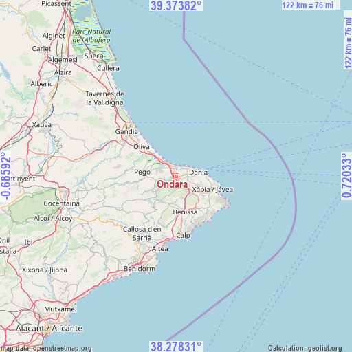
Ondara GPS coordinates[2]
38° 49' 41.412" North, 0° 1' 1.92" East
| Map corner | latitude | longitude |
|---|---|---|
| Upper-left | 39.37382°, | -0.68592° |
| Center: | 38.82817°, | 0.0172° |
| Lower-right: | 38.27831°, | 0.72033° |
| Map W x H: | 121.8×121.8 km | = 75.7×75.7mi |
| max Lat: | 43.74134° ⇑82.9% North |
| Ondara: | 38.82817° |
| min Lat: | ⇓17.1% South 27.64134° |
| min Long | Ondara | max Long |
| -18.00367° | 0.0172° | 4.2899° |
| W 87.1%⇐ | ⇒12.9% E |
Elevation
Elevation of Ondara is 37 m = 121 ft, and this is 561 m = 1841 ft below average elevation for this country.
| Max E: |
1682 m = 5518 ft | 93.2% |
| Avg. | 598 m = 1962 ft | |
| Ondara | 37 m = 121 ft | |
Min E: |
0 m = 0 ft | 6.8% |
See also: Spain elevation on elevation.city.
Geographical zone
Ondara is located in North temperate zone (between Tropic of Cancer and the Arctic Circle). Distance of this Northern Tropic circle is 1711.4 km =1063.4 mi to South.| Distance of | km | miles | from Ondara |
|---|---|---|---|
| North Pole | 5689.8 | 3535.5 | to North |
| Arctic Circle | 3083.9 | 1916.2 | to North |
| Tropic Cancer | 1711.4 | 1063.4 | to South |
| Equator | 4317.3 | 2682.6 | to South |


Nearby cities:
15 places around Ondara: (largest is in red/bold)
• Alcalalí
10 km =6.2 mi,  209°
209°
• Beniarbeig
1.8 km =1.1 mi,  248°
248°
• Benidoleig
5.7 km =3.5 mi,  226°
226°
• Benimeli
5.2 km =3.2 mi,  264°
264°
• Denia
7.8 km =4.8 mi,  79°
79°
• Gata de Gorgos
8.4 km =5.2 mi,  135°
135°
• Jalón
10 km =6.2 mi,  194°
194°
• Orba
8.7 km =5.4 mi, 232°
• Pedreguer
4.2 km =2.6 mi,  159°
159°
• Ráfol de Almunia
6 km =3.7 mi, 262°
• Sagra
7.4 km =4.6 mi, 255°
• Sanet y Negrals
4.5 km =2.8 mi, 257°
• Tormos
8.2 km =5.1 mi, 248°
• Vergel
2.2 km =1.4 mi,  344°
344°
• els Poblets
2.9 km =1.8 mi,  6°
6°
Sources, notices
• [Note1] Compared only with cities in Spain existing in our database
• [Src1] Map data: © OpenStreetMap contributors (CC-BY-SA)
• [Src2] Other city data from geonames.org with taken over terms of usage.
• [Src3] Geographical zone / Annual Mean Temperature by Robert A. Rohde @ Wikipedia
