Vergel geodata
Vergel (Valencia) is a populated place; located in Spain in Europe/Madrid (GMT+2) time zone. With population of 4,372 people, there are 1404 cities with bigger population in this country. Compared to other cities in Spain, 82.7% of cities are located further ↑North; 87% of cities are located further ←West and 95.4% of cities have higher elevation than Vergel. Note1


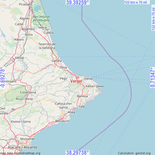
Vergel GPS coordinates[2]
38° 50' 49.524" North, 0° 0' 37.224" East
| Map corner | latitude | longitude |
|---|---|---|
| Upper-left | 39.39259°, | -0.69278° |
| Center: | 38.84709°, | 0.01034° |
| Lower-right: | 38.29738°, | 0.71347° |
| Map W x H: | 121.8×121.8 km | = 75.7×75.7mi |
| max Lat: | 43.74134° ⇑82.7% North |
| Vergel: | 38.84709° |
| min Lat: | ⇓17.3% South 27.64134° |
| min Long | Vergel | max Long |
| -18.00367° | 0.01034° | 4.2899° |
| W 87%⇐ | ⇒13% E |
Elevation
Elevation of Vergel is 23 m = 75 ft, and this is 575 m = 1886 ft below average elevation for this country.
| Max E: |
1682 m = 5518 ft | 95.4% |
| Avg. | 598 m = 1962 ft | |
| Vergel | 23 m = 75 ft | |
Min E: |
0 m = 0 ft | 4.6% |
See also: Spain elevation on elevation.city.
Geographical zone
Vergel is located in North temperate zone (between Tropic of Cancer and the Arctic Circle). Distance of this Northern Tropic circle is 1713.5 km =1064.7 mi to South.| Distance of | km | miles | from Vergel |
|---|---|---|---|
| North Pole | 5687.7 | 3534.2 | to North |
| Arctic Circle | 3081.8 | 1914.9 | to North |
| Tropic Cancer | 1713.5 | 1064.7 | to South |
| Equator | 4319.4 | 2683.9 | to South |


Nearby cities:
15 places around Vergel: (largest is in red/bold)
• Alcalalí
11.6 km =7.2 mi,  202°
202°
• Beniarbeig
3 km =1.9 mi, 201°
• Benidoleig
7 km =4.3 mi,  210°
210°
• Benimeli
5.2 km =3.2 mi,  240°
240°
• Denia
8.3 km =5.2 mi,  94°
94°
• Gata de Gorgos
10.4 km =6.5 mi,  141°
141°
• Ondara
2.2 km =1.4 mi,  164°
164°
• Orba
9.8 km =6.1 mi,  220°
220°
• Pedreguer
6.3 km =3.9 mi, 161°
• Pego
11 km =6.8 mi,  267°
267°
• Ráfol de Almunia
6.1 km =3.8 mi, 241°
• Sagra
7.7 km =4.8 mi, 238°
• Sanet y Negrals
4.9 km =3 mi,  231°
231°
• Tormos
8.7 km =5.4 mi, 234°
• els Poblets
1.2 km =0.7 mi,  51°
51°
Sources, notices
• [Note1] Compared only with cities in Spain existing in our database
• [Src1] Map data: © OpenStreetMap contributors (CC-BY-SA)
• [Src2] Other city data from geonames.org with taken over terms of usage.
• [Src3] Geographical zone / Annual Mean Temperature by Robert A. Rohde @ Wikipedia
