Aldeanueva de San Bartolomé geodata
Aldeanueva de San Bartolomé (Castille-La Mancha) is a seat of a third-order administrative division; located in Spain in Europe/Madrid (GMT+2) time zone. With population of 517 people, there are 3825 cities with bigger population in this country. Compared to other cities in Spain, 75.2% of cities are located further ↑North; 73.9% of cities are located further →East and 56.2% of cities have higher elevation than Aldeanueva de San Bartolomé. Note1
Administrative division(s):
- Level 1: Castille-La Mancha
- Level 2: Province of Toledo
- Level 3: Aldeanueva de San Bartolomé
Current local time in Aldeanueva de San Bartolomé:
11:12 PM, ThursdayDifference from your time zone: hours


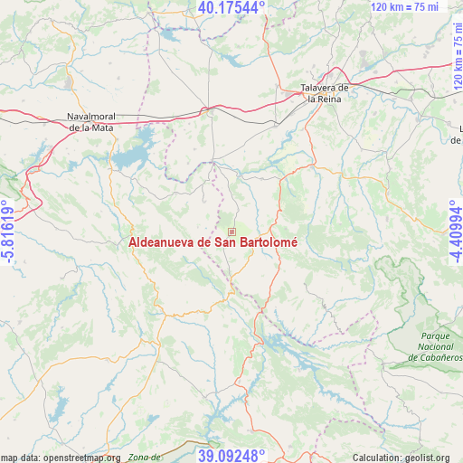
Aldeanueva de San Bartolomé GPS coordinates[2]
39° 38' 9.888" North, 5° 6' 47.052" West
| Map corner | latitude | longitude |
|---|---|---|
| Upper-left | 40.17544°, | -5.81619° |
| Center: | 39.63608°, | -5.11307° |
| Lower-right: | 39.09248°, | -4.40994° |
| Map W x H: | 120.4×120.4 km | = 74.8×74.8mi |
| max Lat: | 43.74134° ⇑75.2% North |
| Aldeanueva de San Bartolomé: | 39.63608° |
| min Lat: | ⇓24.8% South 27.64134° |
| min Long | Aldeanueva de S | max Long |
| -18.00367° | -5.11307° | 4.2899° |
| W 26.1%⇐ | ⇒73.9% E |
Elevation
Elevation of Aldeanueva de San Bartolomé is 580 m = 1903 ft, and this is 18 m = 59 ft below average elevation for this country.
| Max E: |
1682 m = 5518 ft | 56.2% |
| Avg. | 598 m = 1962 ft | |
| Aldeanueva de San Bartolomé | 580 m = 1903 ft | |
Min E: |
0 m = 0 ft | 43.8% |
See also: Spain elevation on elevation.city.
Geographical zone
Aldeanueva de San Bartolomé is located in North temperate zone (between Tropic of Cancer and the Arctic Circle). Distance of this Northern Tropic circle is 1801.2 km =1119.2 mi to South.| Distance of | km | miles | from Aldeanueva de San Bartolomé |
|---|---|---|---|
| North Pole | 5599.9 | 3479.6 | to North |
| Arctic Circle | 2994.1 | 1860.4 | to North |
| Tropic Cancer | 1801.2 | 1119.2 | to South |
| Equator | 4407.1 | 2738.4 | to South |


Nearby cities:
15 places around Aldeanueva de San Bartolomé: (largest is in red/bold)
• Alcolea de Tajo
19.5 km =12.1 mi,  351°
351°
• Aldeanueva de Barbarroya
15.7 km =9.8 mi,  29°
29°
• Azután
16.7 km =10.4 mi,  355°
355°
• Belvis de la Jara
19.5 km =12.1 mi,  46°
46°
• Carrascalejo
8.9 km =5.5 mi,  268°
268°
• El Puente del Arzobispo
19.1 km =11.9 mi,  344°
344°
• Garvín
22.1 km =13.7 mi,  294°
294°
• La Nava de Ricomalillo
10.5 km =6.5 mi,  81°
81°
• Mohedas de la Jara
4.4 km =2.7 mi,  215°
215°
• Navalmoralejo
11.8 km =7.3 mi, 347°
• Puerto de San Vicente
12.6 km =7.8 mi,  180°
180°
• Sevilleja de la Jara
14.5 km =9 mi,  118°
118°
• Valdelacasa de Tajo
17.6 km =10.9 mi,  304°
304°
• Valdeverdeja
21.1 km =13.1 mi,  327°
327°
• Villar del Pedroso
10.5 km =6.5 mi,  317°
317°
Sources, notices
• [Note1] Compared only with cities in Spain existing in our database
• [Src1] Map data: © OpenStreetMap contributors (CC-BY-SA)
• [Src2] Other city data from geonames.org with taken over terms of usage.
• [Src3] Geographical zone / Annual Mean Temperature by Robert A. Rohde @ Wikipedia
