Monturque geodata
Monturque (Andalusia) is a seat of a third-order administrative division; located in Spain in Europe/Madrid (GMT+2) time zone. With population of 2,032 people, there are 2144 cities with bigger population in this country. Compared to other cities in Spain, 91.5% of cities are located further ↑North; 67.1% of cities are located further →East and 70.7% of cities have higher elevation than Monturque. Note1


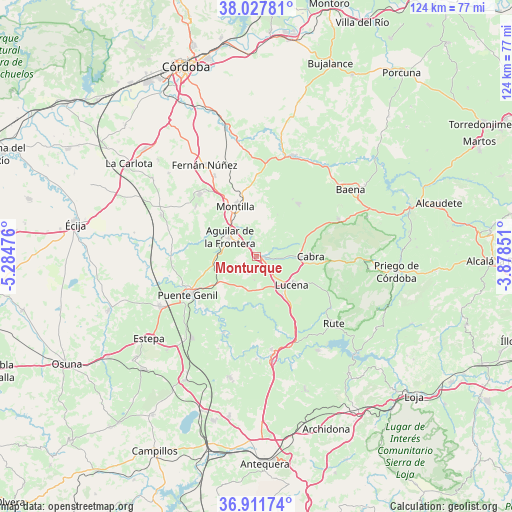
Monturque GPS coordinates[2]
37° 28' 18.696" North, 4° 34' 53.904" West
| Map corner | latitude | longitude |
|---|---|---|
| Upper-left | 38.02781°, | -5.28476° |
| Center: | 37.47186°, | -4.58164° |
| Lower-right: | 36.91174°, | -3.87851° |
| Map W x H: | 124.1×124.1 km | = 77.1×77.1mi |
| max Lat: | 43.74134° ⇑91.5% North |
| Monturque: | 37.47186° |
| min Lat: | ⇓8.5% South 27.64134° |
| min Long | Monturque | max Long |
| -18.00367° | -4.58164° | 4.2899° |
| W 32.9%⇐ | ⇒67.1% E |
Elevation
Elevation of Monturque is 370 m = 1214 ft, and this is 228 m = 748 ft below average elevation for this country.
| Max E: |
1682 m = 5518 ft | 70.7% |
| Avg. | 598 m = 1962 ft | |
| Monturque | 370 m = 1214 ft | |
Min E: |
0 m = 0 ft | 29.3% |
See also: Spain elevation on elevation.city.
Geographical zone
Monturque is located in North temperate zone (between Tropic of Cancer and the Arctic Circle). Distance of this Northern Tropic circle is 1560.6 km =969.7 mi to South.| Distance of | km | miles | from Monturque |
|---|---|---|---|
| North Pole | 5840.6 | 3629.2 | to North |
| Arctic Circle | 3234.7 | 2009.9 | to North |
| Tropic Cancer | 1560.6 | 969.7 | to South |
| Equator | 4166.5 | 2588.9 | to South |


Nearby cities:
15 places around Monturque: (largest is in red/bold)
• Aguilar
8.2 km =5.1 mi,  305°
305°
• Badolatosa
19.9 km =12.4 mi,  203°
203°
• Benamejí
22.9 km =14.2 mi,  171°
171°
• Cabra
12.3 km =7.6 mi,  89°
89°
• Doña Mencía
21.9 km =13.6 mi,  65°
65°
• Encinas Reales
23.5 km =14.6 mi,  159°
159°
• Espejo
23.3 km =14.5 mi,  6°
6°
• La Rambla
20.5 km =12.7 mi,  317°
317°
• Lucena
11 km =6.8 mi,  129°
129°
• Montalbán de Córdoba
19.1 km =11.9 mi, 309°
• Montemayor
22.1 km =13.7 mi,  332°
332°
• Montilla
13.7 km =8.5 mi,  338°
338°
• Moriles
4.5 km =2.8 mi,  210°
210°
• Nueva-Carteya
16.2 km =10.1 mi,  38°
38°
• Puente-Genil
18.7 km =11.6 mi,  240°
240°
Sources, notices
• [Note1] Compared only with cities in Spain existing in our database
• [Src1] Map data: © OpenStreetMap contributors (CC-BY-SA)
• [Src2] Other city data from geonames.org with taken over terms of usage.
• [Src3] Geographical zone / Annual Mean Temperature by Robert A. Rohde @ Wikipedia
