Nueva-Carteya geodata
Nueva-Carteya (Andalusia) is a populated place; located in Spain in Europe/Madrid (GMT+2) time zone. With population of 5,561 people, there are 1201 cities with bigger population in this country. Compared to other cities in Spain, 90.8% of cities are located further ↑North; 65.7% of cities are located further →East and 66.7% of cities have higher elevation than Nueva-Carteya. Note1


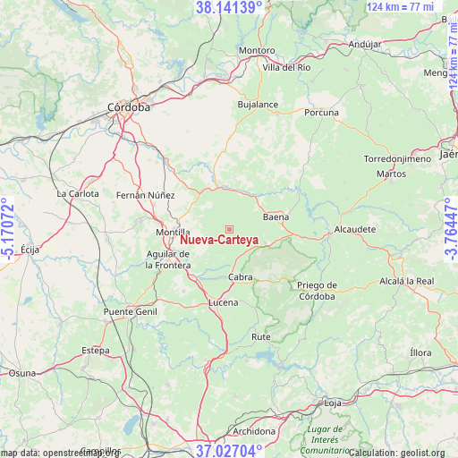
Nueva-Carteya GPS coordinates[2]
37° 35' 10.68" North, 4° 28' 3.324" West
| Map corner | latitude | longitude |
|---|---|---|
| Upper-left | 38.14139°, | -5.17072° |
| Center: | 37.5863°, | -4.46759° |
| Lower-right: | 37.02704°, | -3.76447° |
| Map W x H: | 123.9×123.9 km | = 77×77mi |
| max Lat: | 43.74134° ⇑90.8% North |
| Nueva-Carteya: | 37.5863° |
| min Lat: | ⇓9.2% South 27.64134° |
| min Long | Nueva-Carteya | max Long |
| -18.00367° | -4.46759° | 4.2899° |
| W 34.3%⇐ | ⇒65.7% E |
Elevation
Elevation of Nueva-Carteya is 437 m = 1434 ft, and this is 161 m = 528 ft below average elevation for this country.
| Max E: |
1682 m = 5518 ft | 66.7% |
| Avg. | 598 m = 1962 ft | |
| Nueva-Carteya | 437 m = 1434 ft | |
Min E: |
0 m = 0 ft | 33.3% |
See also: Spain elevation on elevation.city.
Geographical zone
Nueva-Carteya is located in North temperate zone (between Tropic of Cancer and the Arctic Circle). Distance of this Northern Tropic circle is 1573.3 km =977.6 mi to South.| Distance of | km | miles | from Nueva-Carteya |
|---|---|---|---|
| North Pole | 5827.9 | 3621.3 | to North |
| Arctic Circle | 3222 | 2002.1 | to North |
| Tropic Cancer | 1573.3 | 977.6 | to South |
| Equator | 4179.2 | 2596.8 | to South |


Nearby cities:
15 places around Nueva-Carteya: (largest is in red/bold)
• Aguilar
18.5 km =11.5 mi,  244°
244°
• Baena
13.2 km =8.2 mi,  75°
75°
• Cabra
12.9 km =8 mi,  169°
169°
• Carcabuey
23.2 km =14.4 mi,  132°
132°
• Castro del Río
11.7 km =7.3 mi,  354°
354°
• Doña Mencía
10.5 km =6.5 mi,  110°
110°
• Espejo
12.9 km =8 mi,  323°
323°
• La Rambla
24.1 km =15 mi,  275°
275°
• Lucena
19.8 km =12.3 mi,  184°
184°
• Luque
16.9 km =10.5 mi,  100°
100°
• Montemayor
21.4 km =13.3 mi,  288°
288°
• Montilla
15 km =9.3 mi,  269°
269°
• Monturque
16.2 km =10.1 mi,  218°
218°
• Moriles
20.7 km =12.9 mi, 216°
• Zuheros
14.2 km =8.8 mi, 109°
Sources, notices
• [Note1] Compared only with cities in Spain existing in our database
• [Src1] Map data: © OpenStreetMap contributors (CC-BY-SA)
• [Src2] Other city data from geonames.org with taken over terms of usage.
• [Src3] Geographical zone / Annual Mean Temperature by Robert A. Rohde @ Wikipedia
