Espejo geodata
Espejo (Andalusia) is a seat of a third-order administrative division; located in Spain in Europe/Madrid (GMT+2) time zone. With population of 3,796 people, there are 1519 cities with bigger population in this country. Compared to other cities in Spain, 90.2% of cities are located further ↑North; 66.8% of cities are located further →East and 69.1% of cities have higher elevation than Espejo. Note1


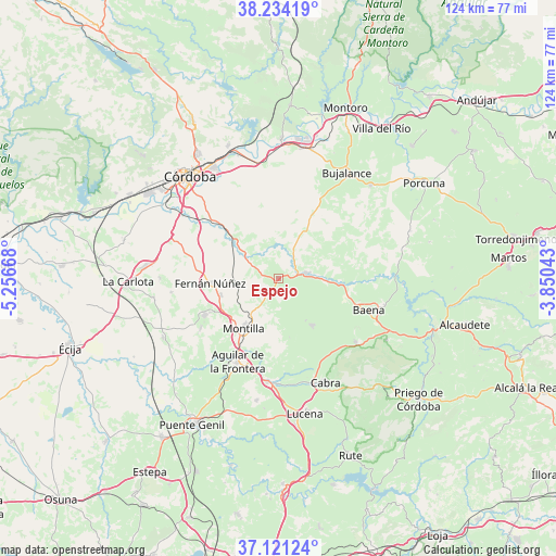
Espejo GPS coordinates[2]
37° 40' 47.28" North, 4° 33' 12.78" West
| Map corner | latitude | longitude |
|---|---|---|
| Upper-left | 38.23419°, | -5.25668° |
| Center: | 37.6798°, | -4.55355° |
| Lower-right: | 37.12124°, | -3.85043° |
| Map W x H: | 123.7×123.7 km | = 76.9×76.9mi |
| max Lat: | 43.74134° ⇑90.2% North |
| Espejo: | 37.6798° |
| min Lat: | ⇓9.8% South 27.64134° |
| min Long | Espejo | max Long |
| -18.00367° | -4.55355° | 4.2899° |
| W 33.2%⇐ | ⇒66.8% E |
Elevation
Elevation of Espejo is 397 m = 1302 ft, and this is 201 m = 659 ft below average elevation for this country.
| Max E: |
1682 m = 5518 ft | 69.1% |
| Avg. | 598 m = 1962 ft | |
| Espejo | 397 m = 1302 ft | |
Min E: |
0 m = 0 ft | 30.9% |
See also: Spain elevation on elevation.city.
Geographical zone
Espejo is located in North temperate zone (between Tropic of Cancer and the Arctic Circle). Distance of this Northern Tropic circle is 1583.7 km =984.1 mi to South.| Distance of | km | miles | from Espejo |
|---|---|---|---|
| North Pole | 5817.5 | 3614.8 | to North |
| Arctic Circle | 3211.6 | 1995.6 | to North |
| Tropic Cancer | 1583.7 | 984.1 | to South |
| Equator | 4189.6 | 2603.3 | to South |


Nearby cities:
15 places around Espejo: (largest is in red/bold)
• Aguilar
20.5 km =12.7 mi,  206°
206°
• Baena
21.5 km =13.4 mi,  109°
109°
• Cabra
25.1 km =15.6 mi,  156°
156°
• Castro del Río
6.5 km =4 mi,  78°
78°
• Doña Mencía
22.4 km =13.9 mi,  128°
128°
• Fernán-Núñez
15.2 km =9.4 mi,  266°
266°
• La Rambla
18.2 km =11.3 mi,  243°
243°
• La Victoria
26.3 km =16.3 mi, 270°
• Montalbán de Córdoba
20.5 km =12.7 mi, 237°
• Montemayor
13.2 km =8.2 mi,  254°
254°
• Montilla
12.8 km =8 mi,  215°
215°
• Monturque
23.3 km =14.5 mi,  186°
186°
• Nueva-Carteya
12.9 km =8 mi,  143°
143°
• San Sebastián de los Ballesteros
24 km =14.9 mi,  263°
263°
• Zuheros
25.9 km =16.1 mi, 125°
Sources, notices
• [Note1] Compared only with cities in Spain existing in our database
• [Src1] Map data: © OpenStreetMap contributors (CC-BY-SA)
• [Src2] Other city data from geonames.org with taken over terms of usage.
• [Src3] Geographical zone / Annual Mean Temperature by Robert A. Rohde @ Wikipedia
