La Rambla geodata
La Rambla (Andalusia) is a populated place; located in Spain in Europe/Madrid (GMT+2) time zone. With population of 7,374 people, there are 993 cities with bigger population in this country. Compared to other cities in Spain, 90.7% of cities are located further ↑North; 69% of cities are located further →East and 72.9% of cities have higher elevation than La Rambla. Note1


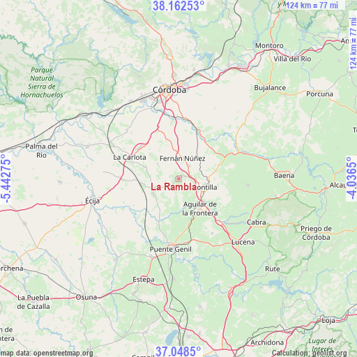
La Rambla GPS coordinates[2]
37° 36' 27.36" North, 4° 44' 22.632" West
| Map corner | latitude | longitude |
|---|---|---|
| Upper-left | 38.16253°, | -5.44275° |
| Center: | 37.6076°, | -4.73962° |
| Lower-right: | 37.0485°, | -4.0365° |
| Map W x H: | 123.9×123.9 km | = 77×77mi |
| max Lat: | 43.74134° ⇑90.7% North |
| La Rambla: | 37.6076° |
| min Lat: | ⇓9.3% South 27.64134° |
| min Long | La Rambla | max Long |
| -18.00367° | -4.73962° | 4.2899° |
| W 31%⇐ | ⇒69% E |
Elevation
Elevation of La Rambla is 334 m = 1096 ft, and this is 264 m = 866 ft below average elevation for this country.
| Max E: |
1682 m = 5518 ft | 72.9% |
| Avg. | 598 m = 1962 ft | |
| La Rambla | 334 m = 1096 ft | |
Min E: |
0 m = 0 ft | 27.1% |
See also: Spain elevation on elevation.city.
Geographical zone
La Rambla is located in North temperate zone (between Tropic of Cancer and the Arctic Circle). Distance of this Northern Tropic circle is 1575.7 km =979.1 mi to South.| Distance of | km | miles | from La Rambla |
|---|---|---|---|
| North Pole | 5825.5 | 3619.8 | to North |
| Arctic Circle | 3219.6 | 2000.6 | to North |
| Tropic Cancer | 1575.7 | 979.1 | to South |
| Equator | 4181.6 | 2598.3 | to South |


Nearby cities:
15 places around La Rambla: (largest is in red/bold)
• Aguilar
12.6 km =7.8 mi,  144°
144°
• Espejo
18.2 km =11.3 mi,  63°
63°
• Fernán-Núñez
7.1 km =4.4 mi,  9°
9°
• Guadalcázar
24.5 km =15.2 mi,  312°
312°
• La Carlota
18.4 km =11.4 mi,  293°
293°
• La Victoria
12.8 km =8 mi, 309°
• Montalbán de Córdoba
3.2 km =2 mi,  195°
195°
• Montemayor
5.8 km =3.6 mi,  39°
39°
• Montilla
9.3 km =5.8 mi,  104°
104°
• Monturque
20.5 km =12.7 mi, 137°
• Moriles
22.3 km =13.9 mi,  148°
148°
• Nueva-Carteya
24.1 km =15 mi, 95°
• Puente-Genil
24.4 km =15.2 mi,  185°
185°
• San Sebastián de los Ballesteros
9 km =5.6 mi,  304°
304°
• Santaella
10.4 km =6.5 mi,  241°
241°
Sources, notices
• [Note1] Compared only with cities in Spain existing in our database
• [Src1] Map data: © OpenStreetMap contributors (CC-BY-SA)
• [Src2] Other city data from geonames.org with taken over terms of usage.
• [Src3] Geographical zone / Annual Mean Temperature by Robert A. Rohde @ Wikipedia
