Lucena geodata
Lucena (Andalusia) is a seat of a third-order administrative division; located in Spain in Europe/Madrid (GMT+2) time zone. With population of 42,248 people, there are 208 cities with bigger population in this country. Compared to other cities in Spain, 91.8% of cities are located further ↑North; 66% of cities are located further →East and 62.5% of cities have higher elevation than Lucena. Note1


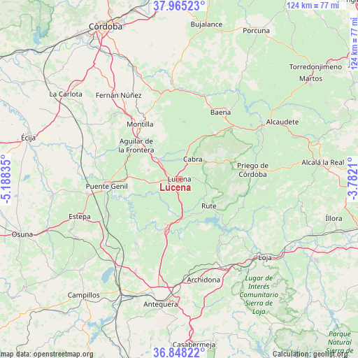
Lucena GPS coordinates[2]
37° 24' 31.716" North, 4° 29' 6.792" West
| Map corner | latitude | longitude |
|---|---|---|
| Upper-left | 37.96523°, | -5.18835° |
| Center: | 37.40881°, | -4.48522° |
| Lower-right: | 36.84822°, | -3.7821° |
| Map W x H: | 124.2×124.2 km | = 77.2×77.2mi |
| max Lat: | 43.74134° ⇑91.8% North |
| Lucena: | 37.40881° |
| min Lat: | ⇓8.2% South 27.64134° |
| min Long | Lucena | max Long |
| -18.00367° | -4.48522° | 4.2899° |
| W 34%⇐ | ⇒66% E |
Elevation
Elevation of Lucena is 493 m = 1617 ft, and this is 105 m = 344 ft below average elevation for this country.
| Max E: |
1682 m = 5518 ft | 62.5% |
| Avg. | 598 m = 1962 ft | |
| Lucena | 493 m = 1617 ft | |
Min E: |
0 m = 0 ft | 37.5% |
See also: Lucena elevation on elevation.city.
Geographical zone
Lucena is located in North temperate zone (between Tropic of Cancer and the Arctic Circle). Distance of this Northern Tropic circle is 1553.6 km =965.4 mi to South.| Distance of | km | miles | from Lucena |
|---|---|---|---|
| North Pole | 5847.6 | 3633.5 | to North |
| Arctic Circle | 3241.7 | 2014.3 | to North |
| Tropic Cancer | 1553.6 | 965.4 | to South |
| Equator | 4159.5 | 2584.6 | to South |


Nearby cities:
15 places around Lucena: (largest is in red/bold)
• Aguilar
19.2 km =11.9 mi,  307°
307°
• Badolatosa
20 km =12.4 mi,  235°
235°
• Benamejí
16.4 km =10.2 mi,  197°
197°
• Cabra
8 km =5 mi,  28°
28°
• Carcabuey
19 km =11.8 mi,  78°
78°
• Cuevas Bajas
19.3 km =12 mi,  180°
180°
• Cuevas de San Marcos
17 km =10.6 mi,  158°
158°
• Doña Mencía
19.7 km =12.2 mi,  35°
35°
• Encinas Reales
15 km =9.3 mi, 181°
• Monturque
11 km =6.8 mi, 309°
• Moriles
11.2 km =7 mi,  286°
286°
• Nueva-Carteya
19.8 km =12.3 mi,  4°
4°
• Palenciana
19.8 km =12.3 mi,  205°
205°
• Rute
13.8 km =8.6 mi,  131°
131°
• Zuheros
21.2 km =13.2 mi,  45°
45°
Sources, notices
• [Note1] Compared only with cities in Spain existing in our database
• [Src1] Map data: © OpenStreetMap contributors (CC-BY-SA)
• [Src2] Other city data from geonames.org with taken over terms of usage.
• [Src3] Geographical zone / Annual Mean Temperature by Robert A. Rohde @ Wikipedia
