Moncofa geodata
Moncofa (Valencia) is a populated place; located in Spain in Europe/Madrid (GMT+2) time zone. With population of 4,930 people, there are 1322 cities with bigger population in this country. Compared to other cities in Spain, 72.8% of cities are located further ↑North; 86% of cities are located further ←West and 98.7% of cities have higher elevation than Moncofa. Note1


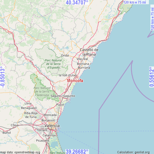
Moncofa GPS coordinates[2]
39° 48' 32.652" North, 0° 8' 49.236" West
| Map corner | latitude | longitude |
|---|---|---|
| Upper-left | 40.34707°, | -0.85013° |
| Center: | 39.80907°, | -0.14701° |
| Lower-right: | 39.26682°, | 0.55612° |
| Map W x H: | 120.1×120.1 km | = 74.6×74.6mi |
| max Lat: | 43.74134° ⇑72.8% North |
| Moncofa: | 39.80907° |
| min Lat: | ⇓27.2% South 27.64134° |
| min Long | Moncofa | max Long |
| -18.00367° | -0.14701° | 4.2899° |
| W 86%⇐ | ⇒14% E |
Elevation
Elevation of Moncofa is 9 m = 30 ft, and this is 589 m = 1932 ft below average elevation for this country.
| Max E: |
1682 m = 5518 ft | 98.7% |
| Avg. | 598 m = 1962 ft | |
| Moncofa | 9 m = 30 ft | |
Min E: |
0 m = 0 ft | 1.3% |
See also: Spain elevation on elevation.city.
Geographical zone
Moncofa is located in North temperate zone (between Tropic of Cancer and the Arctic Circle). Distance of this Northern Tropic circle is 1820.4 km =1131.1 mi to South.| Distance of | km | miles | from Moncofa |
|---|---|---|---|
| North Pole | 5580.7 | 3467.7 | to North |
| Arctic Circle | 2974.8 | 1848.5 | to North |
| Tropic Cancer | 1820.4 | 1131.1 | to South |
| Equator | 4426.4 | 2750.4 | to South |


Nearby cities:
15 places around Moncofa: (largest is in red/bold)
• Alfondeguilla
10.6 km =6.6 mi,  284°
284°
• Almenara
8.9 km =5.5 mi,  222°
222°
• Alquerías del Niño Perdido
9.6 km =6 mi,  8°
8°
• Artana
13.1 km =8.1 mi,  313°
313°
• Benavites
12.2 km =7.6 mi,  226°
226°
• Benifairó de les Valls
13.2 km =8.2 mi, 230°
• Betxí
14.5 km =9 mi,  341°
341°
• Burriana
10.3 km =6.4 mi,  30°
30°
• Chilches
4.6 km =2.9 mi, 229°
• Faura
13.5 km =8.4 mi, 220°
• La Llosa
6.5 km =4 mi, 223°
• Nules
5 km =3.1 mi,  350°
350°
• Quart de les Valls
13.2 km =8.2 mi, 230°
• Quartell
12.8 km =8 mi, 231°
• Villavieja
5.5 km =3.4 mi,  325°
325°
Sources, notices
• [Note1] Compared only with cities in Spain existing in our database
• [Src1] Map data: © OpenStreetMap contributors (CC-BY-SA)
• [Src2] Other city data from geonames.org with taken over terms of usage.
• [Src3] Geographical zone / Annual Mean Temperature by Robert A. Rohde @ Wikipedia
