Villavieja geodata
Villavieja (Valencia) is a populated place; located in Spain in Europe/Madrid (GMT+2) time zone. With population of 3,352 people, there are 1622 cities with bigger population in this country. Compared to other cities in Spain, 72.4% of cities are located further ↑North; 85.7% of cities are located further ←West and 93.7% of cities have higher elevation than Villavieja. Note1
Administrative division(s):
- Level 1: Valencia
- Level 2: Província de Castelló
- Level 3: la Vall d'Uixó


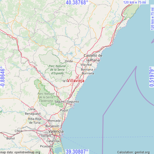
Villavieja GPS coordinates[2]
39° 51' 0" North, 0° 10' 59.988" West
| Map corner | latitude | longitude |
|---|---|---|
| Upper-left | 40.38768°, | -0.88646° |
| Center: | 39.85°, | -0.18333° |
| Lower-right: | 39.30807°, | 0.51979° |
| Map W x H: | 120×120 km | = 74.6×74.6mi |
| max Lat: | 43.74134° ⇑72.4% North |
| Villavieja: | 39.85° |
| min Lat: | ⇓27.6% South 27.64134° |
| min Long | Villavieja | max Long |
| -18.00367° | -0.18333° | 4.2899° |
| W 85.7%⇐ | ⇒14.3% E |
Elevation
Elevation of Villavieja is 33 m = 108 ft, and this is 565 m = 1854 ft below average elevation for this country.
| Max E: |
1682 m = 5518 ft | 93.7% |
| Avg. | 598 m = 1962 ft | |
| Villavieja | 33 m = 108 ft | |
Min E: |
0 m = 0 ft | 6.3% |
See also: Spain elevation on elevation.city.
Geographical zone
Villavieja is located in North temperate zone (between Tropic of Cancer and the Arctic Circle). Distance of this Northern Tropic circle is 1825 km =1134 mi to South.| Distance of | km | miles | from Villavieja |
|---|---|---|---|
| North Pole | 5576.2 | 3464.9 | to North |
| Arctic Circle | 2970.3 | 1845.7 | to North |
| Tropic Cancer | 1825 | 1134 | to South |
| Equator | 4430.9 | 2753.2 | to South |


Nearby cities:
15 places around Villavieja: (largest is in red/bold)
• Alfondeguilla
7.4 km =4.6 mi,  255°
255°
• Almenara
11.5 km =7.1 mi,  194°
194°
• Alquerías del Niño Perdido
6.8 km =4.2 mi,  42°
42°
• Artana
7.8 km =4.8 mi,  305°
305°
• Benavites
14.2 km =8.8 mi,  203°
203°
• Betxí
9.4 km =5.8 mi,  351°
351°
• Burriana
9.4 km =5.8 mi,  62°
62°
• Chilches
7.5 km =4.7 mi,  182°
182°
• Chóvar
11.4 km =7.1 mi,  270°
270°
• Eslida
10.6 km =6.6 mi,  290°
290°
• La Llosa
9.4 km =5.8 mi, 188°
• Moncofa
5.5 km =3.4 mi,  145°
145°
• Nules
2.3 km =1.4 mi,  80°
80°
• Quartell
14.3 km =8.9 mi,  209°
209°
• Vila-real
12.1 km =7.5 mi, 35°
Sources, notices
• [Note1] Compared only with cities in Spain existing in our database
• [Src1] Map data: © OpenStreetMap contributors (CC-BY-SA)
• [Src2] Other city data from geonames.org with taken over terms of usage.
• [Src3] Geographical zone / Annual Mean Temperature by Robert A. Rohde @ Wikipedia
