La Llosa geodata
La Llosa (Valencia) is a populated place; located in Spain in Europe/Madrid (GMT+2) time zone. With population of 917 people, there are 3054 cities with bigger population in this country. Compared to other cities in Spain, 73.3% of cities are located further ↑North; 85.5% of cities are located further ←West and 99.7% of cities have higher elevation than La Llosa. Note1


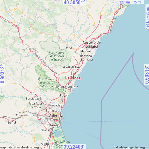
La Llosa GPS coordinates[2]
39° 46' 0.012" North, 0° 12' 0" West
| Map corner | latitude | longitude |
|---|---|---|
| Upper-left | 40.30501°, | -0.90312° |
| Center: | 39.76667°, | -0.2° |
| Lower-right: | 39.22409°, | 0.50313° |
| Map W x H: | 120.2×120.2 km | = 74.7×74.7mi |
| max Lat: | 43.74134° ⇑73.3% North |
| La Llosa: | 39.76667° |
| min Lat: | ⇓26.7% South 27.64134° |
| min Long | La Llosa | max Long |
| -18.00367° | -0.2° | 4.2899° |
| W 85.5%⇐ | ⇒14.5% E |
Elevation
Elevation of La Llosa is 4 m = 13 ft, and this is 594 m = 1949 ft below average elevation for this country.
| Max E: |
1682 m = 5518 ft | 99.7% |
| Avg. | 598 m = 1962 ft | |
| La Llosa | 4 m = 13 ft | |
Min E: |
0 m = 0 ft | 0.3% |
See also: Spain elevation on elevation.city.
Geographical zone
La Llosa is located in North temperate zone (between Tropic of Cancer and the Arctic Circle). Distance of this Northern Tropic circle is 1815.7 km =1128.2 mi to South.| Distance of | km | miles | from La Llosa |
|---|---|---|---|
| North Pole | 5585.4 | 3470.6 | to North |
| Arctic Circle | 2979.5 | 1851.4 | to North |
| Tropic Cancer | 1815.7 | 1128.2 | to South |
| Equator | 4421.6 | 2747.5 | to South |


Nearby cities:
15 places around La Llosa: (largest is in red/bold)
• Alfara de Algimia
12.8 km =8 mi,  270°
270°
• Alfondeguilla
9.3 km =5.8 mi,  322°
322°
• Almenara
2.3 km =1.4 mi,  217°
217°
• Benavites
5.7 km =3.5 mi,  229°
229°
• Benifairó de les Valls
6.8 km =4.2 mi,  236°
236°
• Canet d'En Berenguer
9.4 km =5.8 mi,  188°
188°
• Chilches
2.1 km =1.3 mi,  31°
31°
• Faura
7 km =4.3 mi, 217°
• Moncofa
6.5 km =4 mi,  43°
43°
• Nules
10.4 km =6.5 mi,  21°
21°
• Petrés
12.6 km =7.8 mi, 222°
• Quart de les Valls
6.8 km =4.2 mi, 236°
• Quartell
6.4 km =4 mi, 239°
• Sagunto
10.9 km =6.8 mi,  211°
211°
• Villavieja
9.4 km =5.8 mi,  8°
8°
Sources, notices
• [Note1] Compared only with cities in Spain existing in our database
• [Src1] Map data: © OpenStreetMap contributors (CC-BY-SA)
• [Src2] Other city data from geonames.org with taken over terms of usage.
• [Src3] Geographical zone / Annual Mean Temperature by Robert A. Rohde @ Wikipedia
