Artana geodata
Artana (Valencia) is a seat of a third-order administrative division; located in Spain in Europe/Madrid (GMT+2) time zone. With population of 1,850 people, there are 2259 cities with bigger population in this country. Compared to other cities in Spain, 71.8% of cities are located further ↑North; 85.1% of cities are located further ←West and 77.8% of cities have higher elevation than Artana. Note1


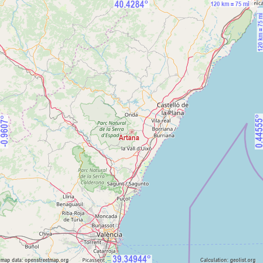
Artana GPS coordinates[2]
39° 53' 27.744" North, 0° 15' 27.288" West
| Map corner | latitude | longitude |
|---|---|---|
| Upper-left | 40.4284°, | -0.9607° |
| Center: | 39.89104°, | -0.25758° |
| Lower-right: | 39.34944°, | 0.44555° |
| Map W x H: | 120×120 km | = 74.6×74.6mi |
| max Lat: | 43.74134° ⇑71.8% North |
| Artana: | 39.89104° |
| min Lat: | ⇓28.2% South 27.64134° |
| min Long | Artana | max Long |
| -18.00367° | -0.25758° | 4.2899° |
| W 85.1%⇐ | ⇒14.9% E |
Elevation
Elevation of Artana is 259 m = 850 ft, and this is 339 m = 1112 ft below average elevation for this country.
| Max E: |
1682 m = 5518 ft | 77.8% |
| Avg. | 598 m = 1962 ft | |
| Artana | 259 m = 850 ft | |
Min E: |
0 m = 0 ft | 22.2% |
See also: Spain elevation on elevation.city.
Geographical zone
Artana is located in North temperate zone (between Tropic of Cancer and the Arctic Circle). Distance of this Northern Tropic circle is 1829.5 km =1136.8 mi to South.| Distance of | km | miles | from Artana |
|---|---|---|---|
| North Pole | 5571.6 | 3462 | to North |
| Arctic Circle | 2965.7 | 1842.8 | to North |
| Tropic Cancer | 1829.5 | 1136.8 | to South |
| Equator | 4435.5 | 2756.1 | to South |


Nearby cities:
15 places around Artana: (largest is in red/bold)
• Alcudia de Veo
8.4 km =5.2 mi,  289°
289°
• Alfondeguilla
6.5 km =4 mi,  186°
186°
• Almedíjar
12.5 km =7.8 mi,  257°
257°
• Alquerías del Niño Perdido
10.9 km =6.8 mi,  87°
87°
• Azuébar
11.3 km =7 mi,  235°
235°
• Betxí
6.8 km =4.2 mi,  46°
46°
• Chilches
13.5 km =8.4 mi,  153°
153°
• Chóvar
6.8 km =4.2 mi,  227°
227°
• Eslida
3.7 km =2.3 mi, 256°
• Moncofa
13.1 km =8.1 mi,  133°
133°
• Nules
9.6 km =6 mi,  115°
115°
• Onda
8.2 km =5.1 mi,  358°
358°
• Ribesalbes
14 km =8.7 mi, 356°
• Tales
7.7 km =4.8 mi,  326°
326°
• Villavieja
7.8 km =4.8 mi, 125°
Sources, notices
• [Note1] Compared only with cities in Spain existing in our database
• [Src1] Map data: © OpenStreetMap contributors (CC-BY-SA)
• [Src2] Other city data from geonames.org with taken over terms of usage.
• [Src3] Geographical zone / Annual Mean Temperature by Robert A. Rohde @ Wikipedia
