Chilches geodata
Chilches (Valencia) is a populated place; located in Spain in Europe/Madrid (GMT+2) time zone. With population of 2,615 people, there are 1854 cities with bigger population in this country. Compared to other cities in Spain, 73.1% of cities are located further ↑North; 85.6% of cities are located further ←West and 97.9% of cities have higher elevation than Chilches. Note1


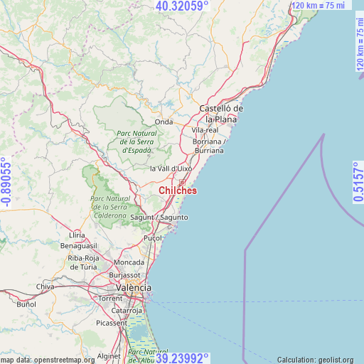
Chilches GPS coordinates[2]
39° 46' 56.568" North, 0° 11' 14.712" West
| Map corner | latitude | longitude |
|---|---|---|
| Upper-left | 40.32059°, | -0.89055° |
| Center: | 39.78238°, | -0.18742° |
| Lower-right: | 39.23992°, | 0.5157° |
| Map W x H: | 120.2×120.2 km | = 74.7×74.7mi |
| max Lat: | 43.74134° ⇑73.1% North |
| Chilches: | 39.78238° |
| min Lat: | ⇓26.9% South 27.64134° |
| min Long | Chilches | max Long |
| -18.00367° | -0.18742° | 4.2899° |
| W 85.6%⇐ | ⇒14.4% E |
Elevation
Elevation of Chilches is 12 m = 39 ft, and this is 586 m = 1923 ft below average elevation for this country.
| Max E: |
1682 m = 5518 ft | 97.9% |
| Avg. | 598 m = 1962 ft | |
| Chilches | 12 m = 39 ft | |
Min E: |
0 m = 0 ft | 2.1% |
See also: Spain elevation on elevation.city.
Geographical zone
Chilches is located in North temperate zone (between Tropic of Cancer and the Arctic Circle). Distance of this Northern Tropic circle is 1817.5 km =1129.3 mi to South.| Distance of | km | miles | from Chilches |
|---|---|---|---|
| North Pole | 5583.7 | 3469.5 | to North |
| Arctic Circle | 2977.8 | 1850.3 | to North |
| Tropic Cancer | 1817.5 | 1129.3 | to South |
| Equator | 4423.4 | 2748.6 | to South |


Nearby cities:
15 places around Chilches: (largest is in red/bold)
• Alfondeguilla
8.8 km =5.5 mi,  309°
309°
• Almenara
4.4 km =2.7 mi,  214°
214°
• Alquerías del Niño Perdido
13.4 km =8.3 mi,  21°
21°
• Benavites
7.6 km =4.7 mi,  224°
224°
• Benifairó de les Valls
8.7 km =5.4 mi,  231°
231°
• Canet d'En Berenguer
11.3 km =7 mi,  192°
192°
• Chóvar
13.4 km =8.3 mi,  304°
304°
• Faura
9.1 km =5.7 mi, 216°
• La Llosa
2.1 km =1.3 mi, 211°
• Moncofa
4.6 km =2.9 mi,  49°
49°
• Nules
8.4 km =5.2 mi, 18°
• Quart de les Valls
8.7 km =5.4 mi, 231°
• Quartell
8.3 km =5.2 mi, 232°
• Sagunto
12.9 km =8 mi, 211°
• Villavieja
7.5 km =4.7 mi,  2°
2°
Sources, notices
• [Note1] Compared only with cities in Spain existing in our database
• [Src1] Map data: © OpenStreetMap contributors (CC-BY-SA)
• [Src2] Other city data from geonames.org with taken over terms of usage.
• [Src3] Geographical zone / Annual Mean Temperature by Robert A. Rohde @ Wikipedia
