Mogente geodata
Mogente (Valencia) is a populated place; located in Spain in Europe/Madrid (GMT+2) time zone. With population of 4,514 people, there are 1382 cities with bigger population in this country. Compared to other cities in Spain, 82.4% of cities are located further ↑North; 79.4% of cities are located further ←West and 73% of cities have higher elevation than Mogente. Note1


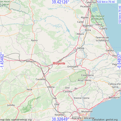
Mogente GPS coordinates[2]
38° 52' 33.528" North, 0° 45' 5.4" West
| Map corner | latitude | longitude |
|---|---|---|
| Upper-left | 39.42126°, | -1.45462° |
| Center: | 38.87598°, | -0.7515° |
| Lower-right: | 38.32649°, | -0.04837° |
| Map W x H: | 121.7×121.7 km | = 75.6×75.6mi |
| max Lat: | 43.74134° ⇑82.4% North |
| Mogente: | 38.87598° |
| min Lat: | ⇓17.6% South 27.64134° |
| min Long | Mogente | max Long |
| -18.00367° | -0.7515° | 4.2899° |
| W 79.4%⇐ | ⇒20.6% E |
Elevation
Elevation of Mogente is 333 m = 1093 ft, and this is 265 m = 869 ft below average elevation for this country.
| Max E: |
1682 m = 5518 ft | 73% |
| Avg. | 598 m = 1962 ft | |
| Mogente | 333 m = 1093 ft | |
Min E: |
0 m = 0 ft | 27% |
See also: Spain elevation on elevation.city.
Geographical zone
Mogente is located in North temperate zone (between Tropic of Cancer and the Arctic Circle). Distance of this Northern Tropic circle is 1716.7 km =1066.7 mi to South.| Distance of | km | miles | from Mogente |
|---|---|---|---|
| North Pole | 5684.5 | 3532.2 | to North |
| Arctic Circle | 3078.6 | 1913 | to North |
| Tropic Cancer | 1716.7 | 1066.7 | to South |
| Equator | 4322.6 | 2685.9 | to South |


Nearby cities:
15 places around Mogente: (largest is in red/bold)
• Agullent
18.6 km =11.6 mi,  108°
108°
• Aielo de Malferit
14.6 km =9.1 mi,  86°
86°
• Anna
18.4 km =11.4 mi,  29°
29°
• Beneixama
19.6 km =12.2 mi,  183°
183°
• Bocairent
16.9 km =10.5 mi,  136°
136°
• Canals
17.4 km =10.8 mi,  56°
56°
• Enguera
12.8 km =8 mi, 25°
• Estubeny
19.3 km =12 mi, 34°
• Fontanars dels Alforins
10.6 km =6.6 mi,  196°
196°
• L'Alcúdia de Crespìns
17.7 km =11 mi, 55°
• L'Olleria
18 km =11.2 mi,  75°
75°
• La Font de la Figuera
14.2 km =8.8 mi,  233°
233°
• Montesa
11.9 km =7.4 mi,  46°
46°
• Ontinyent
14 km =8.7 mi,  115°
115°
• Vallada
5.7 km =3.5 mi,  67°
67°
Sources, notices
• [Note1] Compared only with cities in Spain existing in our database
• [Src1] Map data: © OpenStreetMap contributors (CC-BY-SA)
• [Src2] Other city data from geonames.org with taken over terms of usage.
• [Src3] Geographical zone / Annual Mean Temperature by Robert A. Rohde @ Wikipedia
