La Font de la Figuera geodata
La Font de la Figuera (Valencia) is a populated place; located in Spain in Europe/Madrid (GMT+2) time zone. With population of 2,139 people, there are 2082 cities with bigger population in this country. Compared to other cities in Spain, 83.2% of cities are located further ↑North; 78.1% of cities are located further ←West and 55.6% of cities have higher elevation than La Font de la Figuera. Note1
Administrative division(s):
- Level 1: Valencia
- Level 2: Província de València
- Level 3: Font de la Figuera, la
Current local time in La Font de la Figuera:
10:40 PM, ThursdayDifference from your time zone: hours


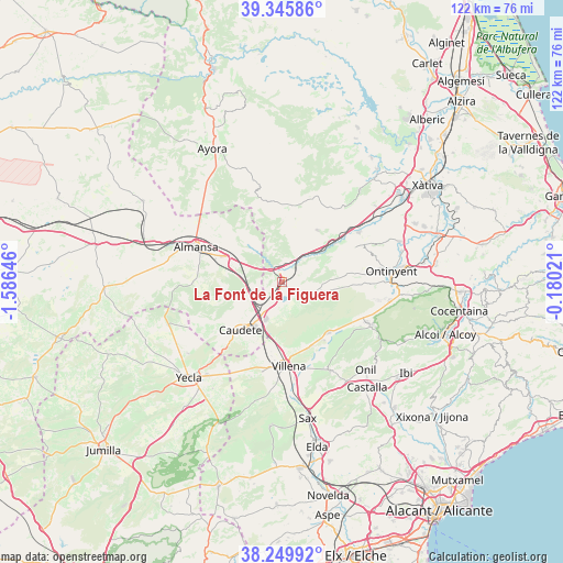
La Font de la Figuera GPS coordinates[2]
38° 48' 0" North, 0° 52' 59.988" West
| Map corner | latitude | longitude |
|---|---|---|
| Upper-left | 39.34586°, | -1.58646° |
| Center: | 38.8°, | -0.88333° |
| Lower-right: | 38.24992°, | -0.18021° |
| Map W x H: | 121.9×121.9 km | = 75.7×75.7mi |
| max Lat: | 43.74134° ⇑83.2% North |
| La Font de la Figuera: | 38.8° |
| min Lat: | ⇓16.8% South 27.64134° |
| min Long | La Font de la F | max Long |
| -18.00367° | -0.88333° | 4.2899° |
| W 78.1%⇐ | ⇒21.9% E |
Elevation
Elevation of La Font de la Figuera is 588 m = 1929 ft, and this is 10 m = 33 ft below average elevation for this country.
| Max E: |
1682 m = 5518 ft | 55.6% |
| Avg. | 598 m = 1962 ft | |
| La Font de la Figuera | 588 m = 1929 ft | |
Min E: |
0 m = 0 ft | 44.4% |
See also: Spain elevation on elevation.city.
Geographical zone
La Font de la Figuera is located in North temperate zone (between Tropic of Cancer and the Arctic Circle). Distance of this Northern Tropic circle is 1708.2 km =1061.4 mi to South.| Distance of | km | miles | from La Font de la Figuera |
|---|---|---|---|
| North Pole | 5692.9 | 3537.4 | to North |
| Arctic Circle | 3087 | 1918.2 | to North |
| Tropic Cancer | 1708.2 | 1061.4 | to South |
| Equator | 4314.2 | 2680.7 | to South |


Nearby cities:
15 places around La Font de la Figuera: (largest is in red/bold)
• Aielo de Malferit
27.6 km =17.1 mi,  70°
70°
• Almansa
20.1 km =12.5 mi,  292°
292°
• Beneixama
15 km =9.3 mi,  137°
137°
• Biar
21.4 km =13.3 mi,  151°
151°
• Bocairent
23.4 km =14.5 mi,  99°
99°
• Caudete
13.7 km =8.5 mi,  220°
220°
• Cañada
15.3 km =9.5 mi,  156°
156°
• Enguera
26.2 km =16.3 mi,  40°
40°
• Fontanars dels Alforins
8.6 km =5.3 mi, 101°
• Mogente
14.2 km =8.8 mi,  53°
53°
• Montesa
26.1 km =16.2 mi, 50°
• Onil
26.6 km =16.5 mi, 136°
• Ontinyent
24.1 km =15 mi,  84°
84°
• Vallada
19.8 km =12.3 mi,  57°
57°
• Villena
18.2 km =11.3 mi,  175°
175°
Sources, notices
• [Note1] Compared only with cities in Spain existing in our database
• [Src1] Map data: © OpenStreetMap contributors (CC-BY-SA)
• [Src2] Other city data from geonames.org with taken over terms of usage.
• [Src3] Geographical zone / Annual Mean Temperature by Robert A. Rohde @ Wikipedia
