Beneixama geodata
Beneixama (Valencia) is a seat of a third-order administrative division; located in Spain in Europe/Madrid (GMT+2) time zone. With population of 1,956 people, there are 2202 cities with bigger population in this country. Compared to other cities in Spain, 84.2% of cities are located further ↑North; 79.2% of cities are located further ←West and 54.9% of cities have higher elevation than Beneixama. Note1


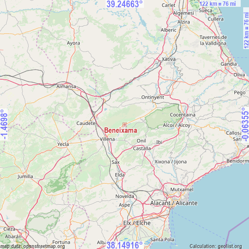
Beneixama GPS coordinates[2]
38° 42' 0" North, 0° 46' 0.012" West
| Map corner | latitude | longitude |
|---|---|---|
| Upper-left | 39.24663°, | -1.4698° |
| Center: | 38.7°, | -0.76667° |
| Lower-right: | 38.14916°, | -0.06355° |
| Map W x H: | 122×122 km | = 75.8×75.8mi |
| max Lat: | 43.74134° ⇑84.2% North |
| Beneixama: | 38.7° |
| min Lat: | ⇓15.8% South 27.64134° |
| min Long | Beneixama | max Long |
| -18.00367° | -0.76667° | 4.2899° |
| W 79.2%⇐ | ⇒20.8% E |
Elevation
Elevation of Beneixama is 596 m = 1955 ft, and this is 2 m = 7 ft below average elevation for this country.
| Max E: |
1682 m = 5518 ft | 54.9% |
| Avg. | 598 m = 1962 ft | |
| Beneixama | 596 m = 1955 ft | |
Min E: |
0 m = 0 ft | 45.1% |
See also: Spain elevation on elevation.city.
Geographical zone
Beneixama is located in North temperate zone (between Tropic of Cancer and the Arctic Circle). Distance of this Northern Tropic circle is 1697.1 km =1054.5 mi to South.| Distance of | km | miles | from Beneixama |
|---|---|---|---|
| North Pole | 5704 | 3544.3 | to North |
| Arctic Circle | 3098.1 | 1925.1 | to North |
| Tropic Cancer | 1697.1 | 1054.5 | to South |
| Equator | 4303 | 2673.8 | to South |


Nearby cities:
15 places around Beneixama: (largest is in red/bold)
• Alfafara
20 km =12.4 mi,  65°
65°
• Biar
7.7 km =4.8 mi,  178°
178°
• Bocairent
15 km =9.3 mi,  60°
60°
• Castalla
14.1 km =8.8 mi,  144°
144°
• Caudete
19.2 km =11.9 mi,  272°
272°
• Cañada
5 km =3.1 mi,  234°
234°
• Fontanars dels Alforins
9.5 km =5.9 mi,  349°
349°
• Ibi
18.8 km =11.7 mi,  116°
116°
• La Font de la Figuera
15 km =9.3 mi,  317°
317°
• Mogente
19.6 km =12.2 mi,  3°
3°
• Onil
11.6 km =7.2 mi, 135°
• Ontinyent
19.4 km =12.1 mi,  45°
45°
• Sax
18.6 km =11.6 mi,  193°
193°
• Vallada
22.7 km =14.1 mi,  16°
16°
• Villena
11.1 km =6.9 mi, 230°
Sources, notices
• [Note1] Compared only with cities in Spain existing in our database
• [Src1] Map data: © OpenStreetMap contributors (CC-BY-SA)
• [Src2] Other city data from geonames.org with taken over terms of usage.
• [Src3] Geographical zone / Annual Mean Temperature by Robert A. Rohde @ Wikipedia
