Marbella geodata
Marbella (Andalusia) is a seat of a third-order administrative division; located in Spain in Europe/Madrid (GMT+2) time zone. With population of 134,623 people, there are 68 cities with bigger population in this country. Compared to other cities in Spain, 98% of cities are located further ↑North; 70.9% of cities are located further →East and 90.5% of cities have higher elevation than Marbella. Note1


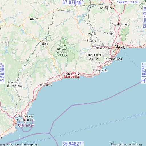
Marbella GPS coordinates[2]
36° 30' 55.548" North, 4° 53' 8.988" West
| Map corner | latitude | longitude |
|---|---|---|
| Upper-left | 37.07846°, | -5.58896° |
| Center: | 36.51543°, | -4.88583° |
| Lower-right: | 35.94827°, | -4.18271° |
| Map W x H: | 125.7×125.7 km | = 78.1×78.1mi |
| max Lat: | 43.74134° ⇑98% North |
| Marbella: | 36.51543° |
| min Lat: | ⇓2% South 27.64134° |
| min Long | Marbella | max Long |
| -18.00367° | -4.88583° | 4.2899° |
| W 29.1%⇐ | ⇒70.9% E |
Elevation
Elevation of Marbella is 57 m = 187 ft, and this is 541 m = 1775 ft below average elevation for this country.
| Max E: |
1682 m = 5518 ft | 90.5% |
| Avg. | 598 m = 1962 ft | |
| Marbella | 57 m = 187 ft | |
Min E: |
0 m = 0 ft | 9.5% |
See also: Marbella elevation on elevation.city.
Geographical zone
Marbella is located in North temperate zone (between Tropic of Cancer and the Arctic Circle). Distance of this Northern Tropic circle is 1454.2 km =903.6 mi to South.| Distance of | km | miles | from Marbella |
|---|---|---|---|
| North Pole | 5946.9 | 3695.2 | to North |
| Arctic Circle | 3341 | 2076 | to North |
| Tropic Cancer | 1454.2 | 903.6 | to South |
| Equator | 4060.1 | 2522.8 | to South |


Nearby cities:
15 places around Marbella: (largest is in red/bold)
• Alhaurín el Grande
22.7 km =14.1 mi,  51°
51°
• Alozaina
23.7 km =14.7 mi,  6°
6°
• Benahavís
14.4 km =8.9 mi,  273°
273°
• Coín
19.7 km =12.2 mi,  35°
35°
• Estepona
25.2 km =15.7 mi,  247°
247°
• Fuengirola
23.5 km =14.6 mi,  83°
83°
• Guaro
16.3 km =10.1 mi,  16°
16°
• Igualeja
24.7 km =15.3 mi,  301°
301°
• Istán
9.4 km =5.8 mi,  322°
322°
• Mijas
23.9 km =14.9 mi,  68°
68°
• Monda
13.6 km =8.5 mi, 20°
• Ojén
6.1 km =3.8 mi,  26°
26°
• San Pedro de Alcántara
9.9 km =6.2 mi, 252°
• Tolox
19.2 km =11.9 mi,  354°
354°
• Yunquera
24.3 km =15.1 mi, 352°
Sources, notices
• [Note1] Compared only with cities in Spain existing in our database
• [Src1] Map data: © OpenStreetMap contributors (CC-BY-SA)
• [Src2] Other city data from geonames.org with taken over terms of usage.
• [Src3] Geographical zone / Annual Mean Temperature by Robert A. Rohde @ Wikipedia
