Coll d'en Rabassa geodata
Coll d'en Rabassa (Balearic Islands) is a section of populated place; located in Spain in Europe/Madrid (GMT+2) time zone. With population of 10,434 people, there are 829 cities with bigger population in this country. Compared to other cities in Spain, 76.3% of cities are located further ↑North; 97.1% of cities are located further ←West and 97.9% of cities have higher elevation than Coll d'en Rabassa. Note1
Administrative division(s):
- Level 1: Balearic Islands
- Level 2: Illes Balears
- Level 3: Palma de Mallorca


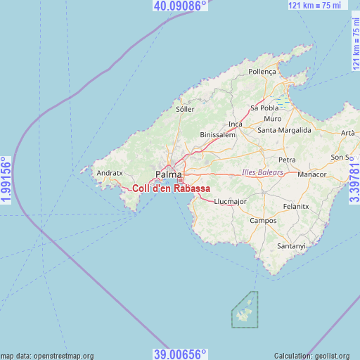
Coll d'en Rabassa GPS coordinates[2]
39° 33' 2.988" North, 2° 41' 40.848" East
| Map corner | latitude | longitude |
|---|---|---|
| Upper-left | 40.09086°, | 1.99156° |
| Center: | 39.55083°, | 2.69468° |
| Lower-right: | 39.00656°, | 3.39781° |
| Map W x H: | 120.6×120.6 km | = 74.9×74.9mi |
| max Lat: | 43.74134° ⇑76.3% North |
| Coll d'en Rabassa: | 39.55083° |
| min Lat: | ⇓23.7% South 27.64134° |
| min Long | Coll d'en Rabas | max Long |
| -18.00367° | 2.69468° | 4.2899° |
| W 97.1%⇐ | ⇒2.9% E |
Elevation
Elevation of Coll d'en Rabassa is 12 m = 39 ft, and this is 586 m = 1923 ft below average elevation for this country.
| Max E: |
1682 m = 5518 ft | 97.9% |
| Avg. | 598 m = 1962 ft | |
| Coll d'en Rabassa | 12 m = 39 ft | |
Min E: |
0 m = 0 ft | 2.1% |
See also: Spain elevation on elevation.city.
Geographical zone
Coll d'en Rabassa is located in North temperate zone (between Tropic of Cancer and the Arctic Circle). Distance of this Northern Tropic circle is 1791.7 km =1113.3 mi to South.| Distance of | km | miles | from Coll d'en Rabassa |
|---|---|---|---|
| North Pole | 5609.4 | 3485.5 | to North |
| Arctic Circle | 3003.5 | 1866.3 | to North |
| Tropic Cancer | 1791.7 | 1113.3 | to South |
| Equator | 4397.6 | 2732.5 | to South |


Nearby cities:
15 places around Coll d'en Rabassa: (largest is in red/bold)
• Algaida
17.2 km =10.7 mi,  86°
86°
• Bunyola
16.2 km =10.1 mi,  1°
1°
• Calvià
16.2 km =10.1 mi,  275°
275°
• Can Pastilla
2.6 km =1.6 mi,  129°
129°
• Consell
16.5 km =10.3 mi,  37°
37°
• Es Molinar
2 km =1.2 mi,  305°
305°
• Esporles
16.4 km =10.2 mi,  322°
322°
• Magaluf
14.4 km =8.9 mi,  252°
252°
• Marratxí
8.3 km =5.2 mi,  18°
18°
• Palma
4.3 km =2.7 mi,  298°
298°
• Palmanova
13.6 km =8.5 mi,  257°
257°
• Puigpunyent
16.5 km =10.3 mi, 299°
• Santa Eugènia
14.8 km =9.2 mi,  56°
56°
• Santa Maria del Camí
13 km =8.1 mi,  31°
31°
• s'Arenal
7.4 km =4.6 mi,  139°
139°
Sources, notices
• [Note1] Compared only with cities in Spain existing in our database
• [Src1] Map data: © OpenStreetMap contributors (CC-BY-SA)
• [Src2] Other city data from geonames.org with taken over terms of usage.
• [Src3] Geographical zone / Annual Mean Temperature by Robert A. Rohde @ Wikipedia
