Llerena geodata
Llerena (Extremadura) is a seat of a third-order administrative division; located in Spain in Europe/Madrid (GMT+2) time zone. With population of 5,716 people, there are 1173 cities with bigger population in this country. Compared to other cities in Spain, 87.1% of cities are located further ↑North; 86.2% of cities are located further →East and 50.8% of cities have higher elevation than Llerena. Note1


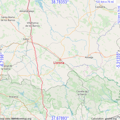
Llerena GPS coordinates[2]
38° 13' 59.988" North, 6° 1' 0.012" West
| Map corner | latitude | longitude |
|---|---|---|
| Upper-left | 38.78353°, | -6.7198° |
| Center: | 38.23333°, | -6.01667° |
| Lower-right: | 37.67893°, | -5.31355° |
| Map W x H: | 122.8×122.8 km | = 76.3×76.3mi |
| max Lat: | 43.74134° ⇑87.1% North |
| Llerena: | 38.23333° |
| min Lat: | ⇓12.9% South 27.64134° |
| min Long | Llerena | max Long |
| -18.00367° | -6.01667° | 4.2899° |
| W 13.8%⇐ | ⇒86.2% E |
Elevation
Elevation of Llerena is 650 m = 2133 ft, and this is 52 m = 171 ft above average elevation for this country.
| Max E: |
1682 m = 5518 ft | 50.8% |
| Llerena | 650 m 2133 ft | |
| Avg. | 598 m = 1962 ft | |
Min E: |
0 m = 0 ft | 49.2% |
See also: Spain elevation on elevation.city.
Geographical zone
Llerena is located in North temperate zone (between Tropic of Cancer and the Arctic Circle). Distance of this Northern Tropic circle is 1645.2 km =1022.3 mi to South.| Distance of | km | miles | from Llerena |
|---|---|---|---|
| North Pole | 5755.9 | 3576.5 | to North |
| Arctic Circle | 3150 | 1957.3 | to North |
| Tropic Cancer | 1645.2 | 1022.3 | to South |
| Equator | 4251.1 | 2641.5 | to South |


Nearby cities:
15 places around Llerena: (largest is in red/bold)
• Ahillones
15 km =9.3 mi,  75°
75°
• Berlanga
18.3 km =11.4 mi,  72°
72°
• Bienvenida
17.6 km =10.9 mi,  294°
294°
• Casas de Reina
5.7 km =3.5 mi,  130°
130°
• Fuente del Arco
13.8 km =8.6 mi, 132°
• Guadalcanal
22.9 km =14.2 mi, 130°
• Maguilla
21.8 km =13.5 mi,  47°
47°
• Montemolín
18.5 km =11.5 mi,  239°
239°
• Puebla del Maestre
17.7 km =11 mi,  199°
199°
• Reina
8.1 km =5 mi, 133°
• Trasierra
5.7 km =3.5 mi,  165°
165°
• Usagre
18.4 km =11.4 mi,  314°
314°
• Valencia de las Torres
19.1 km =11.9 mi,  3°
3°
• Valverde de Llerena
17.6 km =10.9 mi,  96°
96°
• Villagarcía de la Torre
9.4 km =5.8 mi,  321°
321°
Sources, notices
• [Note1] Compared only with cities in Spain existing in our database
• [Src1] Map data: © OpenStreetMap contributors (CC-BY-SA)
• [Src2] Other city data from geonames.org with taken over terms of usage.
• [Src3] Geographical zone / Annual Mean Temperature by Robert A. Rohde @ Wikipedia
