Usagre geodata
Usagre (Extremadura) is a seat of a third-order administrative division; located in Spain in Europe/Madrid (GMT+2) time zone. With population of 1,992 people, there are 2172 cities with bigger population in this country. Compared to other cities in Spain, 86.5% of cities are located further ↑North; 88.1% of cities are located further →East and 56.9% of cities have higher elevation than Usagre. Note1


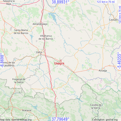
Usagre GPS coordinates[2]
38° 21' 0" North, 6° 10' 0.012" West
| Map corner | latitude | longitude |
|---|---|---|
| Upper-left | 38.89931°, | -6.8698° |
| Center: | 38.35°, | -6.16667° |
| Lower-right: | 37.79649°, | -5.46355° |
| Map W x H: | 122.6×122.6 km | = 76.2×76.2mi |
| max Lat: | 43.74134° ⇑86.5% North |
| Usagre: | 38.35° |
| min Lat: | ⇓13.5% South 27.64134° |
| min Long | Usagre | max Long |
| -18.00367° | -6.16667° | 4.2899° |
| W 11.9%⇐ | ⇒88.1% E |
Elevation
Elevation of Usagre is 567 m = 1860 ft, and this is 31 m = 102 ft below average elevation for this country.
| Max E: |
1682 m = 5518 ft | 56.9% |
| Avg. | 598 m = 1962 ft | |
| Usagre | 567 m = 1860 ft | |
Min E: |
0 m = 0 ft | 43.1% |
See also: Spain elevation on elevation.city.
Geographical zone
Usagre is located in North temperate zone (between Tropic of Cancer and the Arctic Circle). Distance of this Northern Tropic circle is 1658.2 km =1030.4 mi to South.| Distance of | km | miles | from Usagre |
|---|---|---|---|
| North Pole | 5742.9 | 3568.5 | to North |
| Arctic Circle | 3137.1 | 1949.3 | to North |
| Tropic Cancer | 1658.2 | 1030.4 | to South |
| Equator | 4264.1 | 2649.6 | to South |


Nearby cities:
15 places around Usagre: (largest is in red/bold)
• Bienvenida
6.3 km =3.9 mi,  207°
207°
• Calzadilla de Los Barros
14.2 km =8.8 mi,  246°
246°
• Fuente de Cantos
16.1 km =10 mi,  226°
226°
• Hinojosa del Valle
14.9 km =9.3 mi,  354°
354°
• Llera
15.1 km =9.4 mi,  42°
42°
• Llerena
18.4 km =11.4 mi,  134°
134°
• Los Santos de Maimona
21.9 km =13.6 mi,  300°
300°
• Medina de las Torres
20.4 km =12.7 mi,  264°
264°
• Montemolín
22.4 km =13.9 mi,  187°
187°
• Puebla de Sancho Pérez
21.1 km =13.1 mi,  285°
285°
• Ribera del Fresno
23.3 km =14.5 mi,  344°
344°
• Trasierra
23.6 km =14.7 mi,  141°
141°
• Valencia de las Torres
15.4 km =9.6 mi,  66°
66°
• Villagarcía de la Torre
9.2 km =5.7 mi, 127°
• Zafra
23.4 km =14.5 mi, 290°
Sources, notices
• [Note1] Compared only with cities in Spain existing in our database
• [Src1] Map data: © OpenStreetMap contributors (CC-BY-SA)
• [Src2] Other city data from geonames.org with taken over terms of usage.
• [Src3] Geographical zone / Annual Mean Temperature by Robert A. Rohde @ Wikipedia
