Canet d'En Berenguer geodata
Canet d'En Berenguer (Valencia) is a seat of a third-order administrative division; located in Spain in Europe/Madrid (GMT+2) time zone. With population of 3,669 people, there are 1545 cities with bigger population in this country. Compared to other cities in Spain, 74.7% of cities are located further ↑North; 85.3% of cities are located further ←West and 98.9% of cities have higher elevation than Canet d'En Berenguer. Note1
Administrative division(s):
- Level 1: Valencia
- Level 2: Província de València
- Level 3: Canet d'En Berenguer


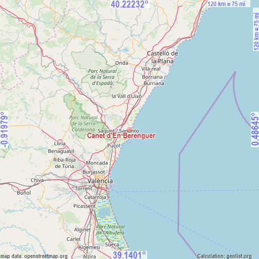
Canet d'En Berenguer GPS coordinates[2]
39° 40' 59.988" North, 0° 13' 0.012" West
| Map corner | latitude | longitude |
|---|---|---|
| Upper-left | 40.22232°, | -0.91979° |
| Center: | 39.68333°, | -0.21667° |
| Lower-right: | 39.1401°, | 0.48645° |
| Map W x H: | 120.3×120.3 km | = 74.8×74.8mi |
| max Lat: | 43.74134° ⇑74.7% North |
| Canet d'En Berenguer: | 39.68333° |
| min Lat: | ⇓25.3% South 27.64134° |
| min Long | Canet d'En Bere | max Long |
| -18.00367° | -0.21667° | 4.2899° |
| W 85.3%⇐ | ⇒14.7% E |
Elevation
Elevation of Canet d'En Berenguer is 8 m = 26 ft, and this is 590 m = 1936 ft below average elevation for this country.
| Max E: |
1682 m = 5518 ft | 98.9% |
| Avg. | 598 m = 1962 ft | |
| Canet d'En Berenguer | 8 m = 26 ft | |
Min E: |
0 m = 0 ft | 1.1% |
See also: Spain elevation on elevation.city.
Geographical zone
Canet d'En Berenguer is located in North temperate zone (between Tropic of Cancer and the Arctic Circle). Distance of this Northern Tropic circle is 1806.5 km =1122.5 mi to South.| Distance of | km | miles | from Canet d'En Berenguer |
|---|---|---|---|
| North Pole | 5594.7 | 3476.4 | to North |
| Arctic Circle | 2988.8 | 1857.2 | to North |
| Tropic Cancer | 1806.5 | 1122.5 | to South |
| Equator | 4412.4 | 2741.7 | to South |


Nearby cities:
15 places around Canet d'En Berenguer: (largest is in red/bold)
• Albalat dels Tarongers
10.2 km =6.3 mi,  280°
280°
• Almenara
7.4 km =4.6 mi,  0°
0°
• Benavites
6.2 km =3.9 mi,  332°
332°
• Benifairó de les Valls
7 km =4.3 mi,  322°
322°
• Chilches
11.3 km =7 mi,  12°
12°
• Estivella
12 km =7.5 mi,  288°
288°
• Faura
4.7 km =2.9 mi, 322°
• Gilet
8.6 km =5.3 mi,  270°
270°
• Grao de Murviedro
5 km =3.1 mi,  202°
202°
• La Llosa
9.4 km =5.8 mi, 8°
• Petrés
7.1 km =4.4 mi, 270°
• Puçol
10.3 km =6.4 mi,  223°
223°
• Quart de les Valls
7 km =4.3 mi, 322°
• Quartell
7.3 km =4.5 mi, 325°
• Sagunto
4.3 km =2.7 mi, 270°
Sources, notices
• [Note1] Compared only with cities in Spain existing in our database
• [Src1] Map data: © OpenStreetMap contributors (CC-BY-SA)
• [Src2] Other city data from geonames.org with taken over terms of usage.
• [Src3] Geographical zone / Annual Mean Temperature by Robert A. Rohde @ Wikipedia
