Jaraicejo geodata
Jaraicejo (Extremadura) is a seat of a third-order administrative division; located in Spain in Europe/Madrid (GMT+2) time zone. With population of 621 people, there are 3565 cities with bigger population in this country. Compared to other cities in Spain, 74.9% of cities are located further ↑North; 83.4% of cities are located further →East and 62.4% of cities have higher elevation than Jaraicejo. Note1


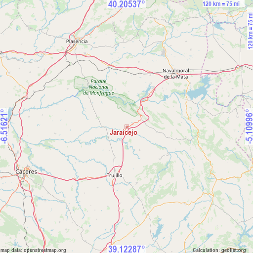
Jaraicejo GPS coordinates[2]
39° 39' 58.464" North, 5° 48' 47.088" West
| Map corner | latitude | longitude |
|---|---|---|
| Upper-left | 40.20537°, | -6.51621° |
| Center: | 39.66624°, | -5.81308° |
| Lower-right: | 39.12287°, | -5.10996° |
| Map W x H: | 120.4×120.4 km | = 74.8×74.8mi |
| max Lat: | 43.74134° ⇑74.9% North |
| Jaraicejo: | 39.66624° |
| min Lat: | ⇓25.1% South 27.64134° |
| min Long | Jaraicejo | max Long |
| -18.00367° | -5.81308° | 4.2899° |
| W 16.6%⇐ | ⇒83.4% E |
Elevation
Elevation of Jaraicejo is 494 m = 1621 ft, and this is 104 m = 341 ft below average elevation for this country.
| Max E: |
1682 m = 5518 ft | 62.4% |
| Avg. | 598 m = 1962 ft | |
| Jaraicejo | 494 m = 1621 ft | |
Min E: |
0 m = 0 ft | 37.6% |
See also: Spain elevation on elevation.city.
Geographical zone
Jaraicejo is located in North temperate zone (between Tropic of Cancer and the Arctic Circle). Distance of this Northern Tropic circle is 1804.6 km =1121.3 mi to South.| Distance of | km | miles | from Jaraicejo |
|---|---|---|---|
| North Pole | 5596.6 | 3477.6 | to North |
| Arctic Circle | 2990.7 | 1858.3 | to North |
| Tropic Cancer | 1804.6 | 1121.3 | to South |
| Equator | 4410.5 | 2740.6 | to South |


Nearby cities:
15 places around Jaraicejo: (largest is in red/bold)
• Aldeacentenera
22.1 km =13.7 mi,  134°
134°
• Almaraz
20.1 km =12.5 mi,  35°
35°
• Belvis de Monroy
24.4 km =15.2 mi,  45°
45°
• Campillo de Deleitosa
20.8 km =12.9 mi,  78°
78°
• Casas de Miravete
9 km =5.6 mi, 41°
• Deleitosa
14.5 km =9 mi,  99°
99°
• Higuera
14.1 km =8.8 mi,  62°
62°
• Mesas de Ibor
24.9 km =15.5 mi,  66°
66°
• Romangordo
12.8 km =8 mi, 48°
• Saucedilla
23.8 km =14.8 mi,  29°
29°
• Serrejón
16.8 km =10.4 mi,  3°
3°
• Torrecillas de la Tiesa
12.5 km =7.8 mi,  150°
150°
• Torrejón el Rubio
20.6 km =12.8 mi,  304°
304°
• Trujillo
23.9 km =14.9 mi,  194°
194°
• Valdecañas de Tajo
19.5 km =12.1 mi, 58°
Sources, notices
• [Note1] Compared only with cities in Spain existing in our database
• [Src1] Map data: © OpenStreetMap contributors (CC-BY-SA)
• [Src2] Other city data from geonames.org with taken over terms of usage.
• [Src3] Geographical zone / Annual Mean Temperature by Robert A. Rohde @ Wikipedia
