Deleitosa geodata
Deleitosa (Extremadura) is a seat of a third-order administrative division; located in Spain in Europe/Madrid (GMT+2) time zone. With population of 836 people, there are 3155 cities with bigger population in this country. Compared to other cities in Spain, 75.1% of cities are located further ↑North; 80.8% of cities are located further →East and 56.9% of cities have higher elevation than Deleitosa. Note1


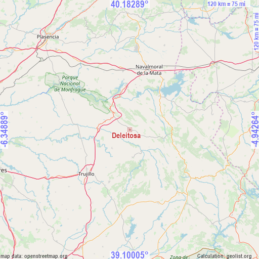
Deleitosa GPS coordinates[2]
39° 38' 36.924" North, 5° 38' 44.736" West
| Map corner | latitude | longitude |
|---|---|---|
| Upper-left | 40.18289°, | -6.34889° |
| Center: | 39.64359°, | -5.64576° |
| Lower-right: | 39.10005°, | -4.94264° |
| Map W x H: | 120.4×120.4 km | = 74.8×74.8mi |
| max Lat: | 43.74134° ⇑75.1% North |
| Deleitosa: | 39.64359° |
| min Lat: | ⇓24.9% South 27.64134° |
| min Long | Deleitosa | max Long |
| -18.00367° | -5.64576° | 4.2899° |
| W 19.2%⇐ | ⇒80.8% E |
Elevation
Elevation of Deleitosa is 567 m = 1860 ft, and this is 31 m = 102 ft below average elevation for this country.
| Max E: |
1682 m = 5518 ft | 56.9% |
| Avg. | 598 m = 1962 ft | |
| Deleitosa | 567 m = 1860 ft | |
Min E: |
0 m = 0 ft | 43.1% |
See also: Spain elevation on elevation.city.
Geographical zone
Deleitosa is located in North temperate zone (between Tropic of Cancer and the Arctic Circle). Distance of this Northern Tropic circle is 1802 km =1119.7 mi to South.| Distance of | km | miles | from Deleitosa |
|---|---|---|---|
| North Pole | 5599.1 | 3479.1 | to North |
| Arctic Circle | 2993.2 | 1859.9 | to North |
| Tropic Cancer | 1802 | 1119.7 | to South |
| Equator | 4408 | 2739 | to South |


Nearby cities:
15 places around Deleitosa: (largest is in red/bold)
• Aldeacentenera
13 km =8.1 mi,  173°
173°
• Almaraz
19.2 km =11.9 mi,  351°
351°
• Belvis de Monroy
19.8 km =12.3 mi,  9°
9°
• Cabañas del Castillo
15.6 km =9.7 mi,  132°
132°
• Campillo de Deleitosa
9 km =5.6 mi,  42°
42°
• Casas de Miravete
12.5 km =7.8 mi,  317°
317°
• Castañar de Ibor
19.7 km =12.2 mi,  94°
94°
• Fresnedoso de Ibor
12.5 km =7.8 mi,  68°
68°
• Higuera
9.3 km =5.8 mi, 348°
• Jaraicejo
14.5 km =9 mi,  279°
279°
• Mesas de Ibor
15.1 km =9.4 mi,  34°
34°
• Robledollano
12.3 km =7.6 mi,  107°
107°
• Romangordo
11.9 km =7.4 mi,  336°
336°
• Torrecillas de la Tiesa
11.8 km =7.3 mi,  224°
224°
• Valdecañas de Tajo
13 km =8.1 mi, 9°
Sources, notices
• [Note1] Compared only with cities in Spain existing in our database
• [Src1] Map data: © OpenStreetMap contributors (CC-BY-SA)
• [Src2] Other city data from geonames.org with taken over terms of usage.
• [Src3] Geographical zone / Annual Mean Temperature by Robert A. Rohde @ Wikipedia
