Aldeacentenera geodata
Aldeacentenera (Extremadura) is a seat of a third-order administrative division; located in Spain in Europe/Madrid (GMT+2) time zone. With population of 904 people, there are 3063 cities with bigger population in this country. Compared to other cities in Spain, 76.6% of cities are located further ↑North; 80.6% of cities are located further →East and 57% of cities have higher elevation than Aldeacentenera. Note1
Administrative division(s):
- Level 1: Extremadura
- Level 2: Provincia de Cáceres
- Level 3: Aldeacentenera


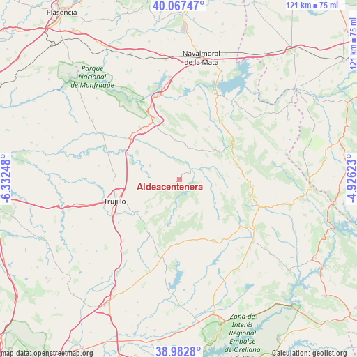
Aldeacentenera GPS coordinates[2]
39° 31' 38.1" North, 5° 37' 45.696" West
| Map corner | latitude | longitude |
|---|---|---|
| Upper-left | 40.06747°, | -6.33248° |
| Center: | 39.52725°, | -5.62936° |
| Lower-right: | 38.9828°, | -4.92623° |
| Map W x H: | 120.6×120.6 km | = 74.9×74.9mi |
| max Lat: | 43.74134° ⇑76.6% North |
| Aldeacentenera: | 39.52725° |
| min Lat: | ⇓23.4% South 27.64134° |
| min Long | Aldeacentenera | max Long |
| -18.00367° | -5.62936° | 4.2899° |
| W 19.4%⇐ | ⇒80.6% E |
Elevation
Elevation of Aldeacentenera is 566 m = 1857 ft, and this is 32 m = 105 ft below average elevation for this country.
| Max E: |
1682 m = 5518 ft | 57% |
| Avg. | 598 m = 1962 ft | |
| Aldeacentenera | 566 m = 1857 ft | |
Min E: |
0 m = 0 ft | 43% |
See also: Spain elevation on elevation.city.
Geographical zone
Aldeacentenera is located in North temperate zone (between Tropic of Cancer and the Arctic Circle). Distance of this Northern Tropic circle is 1789.1 km =1111.7 mi to South.| Distance of | km | miles | from Aldeacentenera |
|---|---|---|---|
| North Pole | 5612 | 3487.1 | to North |
| Arctic Circle | 3006.2 | 1868 | to North |
| Tropic Cancer | 1789.1 | 1111.7 | to South |
| Equator | 4395 | 2730.9 | to South |


Nearby cities:
15 places around Aldeacentenera: (largest is in red/bold)
• Berzocana
17.6 km =10.9 mi,  124°
124°
• Cabañas del Castillo
10.3 km =6.4 mi,  77°
77°
• Campillo de Deleitosa
20.1 km =12.5 mi,  13°
13°
• Castañar de Ibor
21.4 km =13.3 mi,  58°
58°
• Conquista de la Sierra
21.6 km =13.4 mi,  204°
204°
• Deleitosa
13 km =8.1 mi,  353°
353°
• Fresnedoso de Ibor
20.3 km =12.6 mi,  30°
30°
• Garcíaz
12.7 km =7.9 mi,  179°
179°
• Herguijuela
20.4 km =12.7 mi,  213°
213°
• Jaraicejo
22.1 km =13.7 mi,  314°
314°
• Madroñera
15.7 km =9.8 mi,  223°
223°
• Navalvillar de Ibor
19.6 km =12.2 mi,  71°
71°
• Navezuelas
16.6 km =10.3 mi,  96°
96°
• Robledollano
13.8 km =8.6 mi,  48°
48°
• Torrecillas de la Tiesa
10.7 km =6.6 mi,  295°
295°
Sources, notices
• [Note1] Compared only with cities in Spain existing in our database
• [Src1] Map data: © OpenStreetMap contributors (CC-BY-SA)
• [Src2] Other city data from geonames.org with taken over terms of usage.
• [Src3] Geographical zone / Annual Mean Temperature by Robert A. Rohde @ Wikipedia
