Alamedilla geodata
Alamedilla (Andalusia) is a seat of a third-order administrative division; located in Spain in Europe/Madrid (GMT+2) time zone. With population of 815 people, there are 3183 cities with bigger population in this country. Compared to other cities in Spain, 90.9% of cities are located further ↑North; 51.1% of cities are located further ←West and 76.3% of cities have lower elevation than Alamedilla. Note1


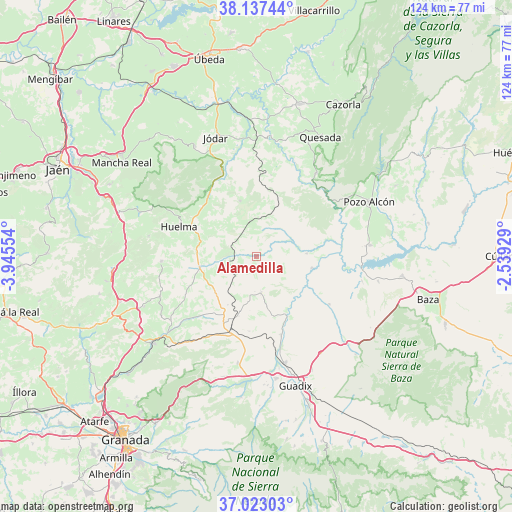
Alamedilla GPS coordinates[2]
37° 34' 56.352" North, 3° 14' 32.676" West
| Map corner | latitude | longitude |
|---|---|---|
| Upper-left | 38.13744°, | -3.94554° |
| Center: | 37.58232°, | -3.24241° |
| Lower-right: | 37.02303°, | -2.53929° |
| Map W x H: | 123.9×123.9 km | = 77×77mi |
| max Lat: | 43.74134° ⇑90.9% North |
| Alamedilla: | 37.58232° |
| min Lat: | ⇓9.1% South 27.64134° |
| min Long | Alamedilla | max Long |
| -18.00367° | -3.24241° | 4.2899° |
| W 51.1%⇐ | ⇒48.9% E |
Elevation
Elevation of Alamedilla is 862 m = 2828 ft, and this is 264 m = 866 ft above average elevation for this country.
| Max E: |
1682 m = 5518 ft | 23.7% |
| Alamedilla | 862 m 2828 ft | |
| Avg. | 598 m = 1962 ft | |
Min E: |
0 m = 0 ft | 76.3% |
See also: Spain elevation on elevation.city.
Geographical zone
Alamedilla is located in North temperate zone (between Tropic of Cancer and the Arctic Circle). Distance of this Northern Tropic circle is 1572.8 km =977.3 mi to South.| Distance of | km | miles | from Alamedilla |
|---|---|---|---|
| North Pole | 5828.3 | 3621.5 | to North |
| Arctic Circle | 3222.4 | 2002.3 | to North |
| Tropic Cancer | 1572.8 | 977.3 | to South |
| Equator | 4178.8 | 2596.6 | to South |


Nearby cities:
15 places around Alamedilla: (largest is in red/bold)
• Alicún de Ortega
9.8 km =6.1 mi,  72°
72°
• Bélmez de la Moraleda
20 km =12.4 mi,  321°
321°
• Cabra del Santo Cristo
14.1 km =8.8 mi,  343°
343°
• Dehesas de Guadix
12.3 km =7.6 mi,  86°
86°
• Fonelas
20.1 km =12.5 mi,  161°
161°
• Gobernador
13.5 km =8.4 mi,  211°
211°
• Gorafe
21 km =13 mi,  122°
122°
• Guadahortuna
14 km =8.7 mi,  258°
258°
• Huelma
20.5 km =12.7 mi,  290°
290°
• Huélago
18.2 km =11.3 mi,  185°
185°
• Larva
20.1 km =12.5 mi,  9°
9°
• Pedro Martínez
8.9 km =5.5 mi,  173°
173°
• Piñar
23.1 km =14.4 mi,  228°
228°
• Torre-Cardela
13.2 km =8.2 mi, 229°
• Villanueva de las Torres
13.8 km =8.6 mi,  101°
101°
Sources, notices
• [Note1] Compared only with cities in Spain existing in our database
• [Src1] Map data: © OpenStreetMap contributors (CC-BY-SA)
• [Src2] Other city data from geonames.org with taken over terms of usage.
• [Src3] Geographical zone / Annual Mean Temperature by Robert A. Rohde @ Wikipedia
