Hornachos geodata
Hornachos (Extremadura) is a seat of a third-order administrative division; located in Spain in Europe/Madrid (GMT+2) time zone. With population of 3,799 people, there are 1517 cities with bigger population in this country. Compared to other cities in Spain, 85.3% of cities are located further ↑North; 86.9% of cities are located further →East and 63.4% of cities have higher elevation than Hornachos. Note1


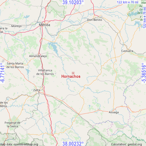
Hornachos GPS coordinates[2]
38° 33' 15.408" North, 6° 4' 5.844" West
| Map corner | latitude | longitude |
|---|---|---|
| Upper-left | 39.10203°, | -6.77141° |
| Center: | 38.55428°, | -6.06829° |
| Lower-right: | 38.00232°, | -5.36516° |
| Map W x H: | 122.3×122.3 km | = 76×76mi |
| max Lat: | 43.74134° ⇑85.3% North |
| Hornachos: | 38.55428° |
| min Lat: | ⇓14.7% South 27.64134° |
| min Long | Hornachos | max Long |
| -18.00367° | -6.06829° | 4.2899° |
| W 13.1%⇐ | ⇒86.9% E |
Elevation
Elevation of Hornachos is 482 m = 1581 ft, and this is 116 m = 381 ft below average elevation for this country.
| Max E: |
1682 m = 5518 ft | 63.4% |
| Avg. | 598 m = 1962 ft | |
| Hornachos | 482 m = 1581 ft | |
Min E: |
0 m = 0 ft | 36.6% |
See also: Spain elevation on elevation.city.
Geographical zone
Hornachos is located in North temperate zone (between Tropic of Cancer and the Arctic Circle). Distance of this Northern Tropic circle is 1680.9 km =1044.5 mi to South.| Distance of | km | miles | from Hornachos |
|---|---|---|---|
| North Pole | 5720.2 | 3554.4 | to North |
| Arctic Circle | 3114.3 | 1935.1 | to North |
| Tropic Cancer | 1680.9 | 1044.5 | to South |
| Equator | 4286.8 | 2663.7 | to South |


Nearby cities:
15 places around Hornachos: (largest is in red/bold)
• Campillo de Llerena
21.4 km =13.3 mi,  105°
105°
• El Casar
12.7 km =7.9 mi,  101°
101°
• Hinojosa del Valle
12.7 km =7.9 mi,  231°
231°
• Llera
11.7 km =7.3 mi,  172°
172°
• Manchita
29.2 km =18.1 mi,  8°
8°
• Oliva de Mérida
26.7 km =16.6 mi,  349°
349°
• Palomas
16.4 km =10.2 mi,  339°
339°
• Puebla de la Reina
12.6 km =7.8 mi, 346°
• Puebla del Prior
11.2 km =7 mi,  279°
279°
• Ribera del Fresno
14.7 km =9.1 mi,  268°
268°
• Usagre
24.3 km =15.1 mi,  200°
200°
• Valencia de las Torres
17.5 km =10.9 mi,  161°
161°
• Valle de la Serena
29.1 km =18.1 mi,  53°
53°
• Villafranca de los Barros
23.5 km =14.6 mi, 271°
• Villagarcía de la Torre
28.3 km =17.6 mi,  182°
182°
Sources, notices
• [Note1] Compared only with cities in Spain existing in our database
• [Src1] Map data: © OpenStreetMap contributors (CC-BY-SA)
• [Src2] Other city data from geonames.org with taken over terms of usage.
• [Src3] Geographical zone / Annual Mean Temperature by Robert A. Rohde @ Wikipedia
