Puebla del Prior geodata
Puebla del Prior (Extremadura) is a seat of a third-order administrative division; located in Spain in Europe/Madrid (GMT+2) time zone. With population of 557 people, there are 3722 cities with bigger population in this country. Compared to other cities in Spain, 85.2% of cities are located further ↑North; 88.5% of cities are located further →East and 69.6% of cities have higher elevation than Puebla del Prior. Note1
Administrative division(s):
- Level 1: Extremadura
- Level 2: Provincia de Badajoz
- Level 3: Puebla del Prior


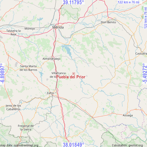
Puebla del Prior GPS coordinates[2]
38° 34' 13.152" North, 6° 11' 45.024" West
| Map corner | latitude | longitude |
|---|---|---|
| Upper-left | 39.11795°, | -6.89897° |
| Center: | 38.57032°, | -6.19584° |
| Lower-right: | 38.01849°, | -5.49272° |
| Map W x H: | 122.2×122.2 km | = 75.9×75.9mi |
| max Lat: | 43.74134° ⇑85.2% North |
| Puebla del Prior: | 38.57032° |
| min Lat: | ⇓14.8% South 27.64134° |
| min Long | Puebla del Prio | max Long |
| -18.00367° | -6.19584° | 4.2899° |
| W 11.5%⇐ | ⇒88.5% E |
Elevation
Elevation of Puebla del Prior is 388 m = 1273 ft, and this is 210 m = 689 ft below average elevation for this country.
| Max E: |
1682 m = 5518 ft | 69.6% |
| Avg. | 598 m = 1962 ft | |
| Puebla del Prior | 388 m = 1273 ft | |
Min E: |
0 m = 0 ft | 30.4% |
See also: Spain elevation on elevation.city.
Geographical zone
Puebla del Prior is located in North temperate zone (between Tropic of Cancer and the Arctic Circle). Distance of this Northern Tropic circle is 1682.7 km =1045.6 mi to South.| Distance of | km | miles | from Puebla del Prior |
|---|---|---|---|
| North Pole | 5718.4 | 3553.2 | to North |
| Arctic Circle | 3112.6 | 1934.1 | to North |
| Tropic Cancer | 1682.7 | 1045.6 | to South |
| Equator | 4288.6 | 2664.8 | to South |


Nearby cities:
15 places around Puebla del Prior: (largest is in red/bold)
• Alange
24.3 km =15.1 mi,  349°
349°
• Almendralejo
22.3 km =13.9 mi,  304°
304°
• El Casar
23.9 km =14.9 mi,  100°
100°
• Fuente del Maestre
22.4 km =13.9 mi,  257°
257°
• Hinojosa del Valle
9.7 km =6 mi,  173°
173°
• Hornachos
11.2 km =7 mi, 99°
• Llera
18.4 km =11.4 mi,  136°
136°
• Los Santos de Maimona
21.1 km =13.1 mi,  230°
230°
• Palomas
14.6 km =9.1 mi,  21°
21°
• Puebla de la Reina
13.3 km =8.3 mi,  37°
37°
• Ribera del Fresno
4.2 km =2.6 mi,  240°
240°
• Usagre
24.6 km =15.3 mi, 174°
• Valencia de las Torres
24.8 km =15.4 mi, 137°
• Villafranca de los Barros
12.4 km =7.7 mi,  265°
265°
• Zafra
25.1 km =15.6 mi, 230°
Sources, notices
• [Note1] Compared only with cities in Spain existing in our database
• [Src1] Map data: © OpenStreetMap contributors (CC-BY-SA)
• [Src2] Other city data from geonames.org with taken over terms of usage.
• [Src3] Geographical zone / Annual Mean Temperature by Robert A. Rohde @ Wikipedia
