Palomas geodata
Palomas (Extremadura) is a seat of a third-order administrative division; located in Spain in Europe/Madrid (GMT+2) time zone. With population of 731 people, there are 3344 cities with bigger population in this country. Compared to other cities in Spain, 84.3% of cities are located further ↑North; 87.8% of cities are located further →East and 73.8% of cities have higher elevation than Palomas. Note1


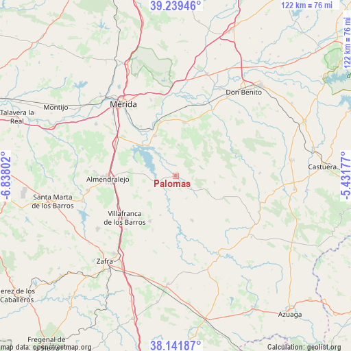
Palomas GPS coordinates[2]
38° 41' 33.972" North, 6° 8' 5.64" West
| Map corner | latitude | longitude |
|---|---|---|
| Upper-left | 39.23946°, | -6.83802° |
| Center: | 38.69277°, | -6.1349° |
| Lower-right: | 38.14187°, | -5.43177° |
| Map W x H: | 122×122 km | = 75.8×75.8mi |
| max Lat: | 43.74134° ⇑84.3% North |
| Palomas: | 38.69277° |
| min Lat: | ⇓15.7% South 27.64134° |
| min Long | Palomas | max Long |
| -18.00367° | -6.1349° | 4.2899° |
| W 12.2%⇐ | ⇒87.8% E |
Elevation
Elevation of Palomas is 318 m = 1043 ft, and this is 280 m = 919 ft below average elevation for this country.
| Max E: |
1682 m = 5518 ft | 73.8% |
| Avg. | 598 m = 1962 ft | |
| Palomas | 318 m = 1043 ft | |
Min E: |
0 m = 0 ft | 26.2% |
See also: Spain elevation on elevation.city.
Geographical zone
Palomas is located in North temperate zone (between Tropic of Cancer and the Arctic Circle). Distance of this Northern Tropic circle is 1696.3 km =1054 mi to South.| Distance of | km | miles | from Palomas |
|---|---|---|---|
| North Pole | 5704.8 | 3544.8 | to North |
| Arctic Circle | 3098.9 | 1925.6 | to North |
| Tropic Cancer | 1696.3 | 1054 | to South |
| Equator | 4302.2 | 2673.3 | to South |


Nearby cities:
15 places around Palomas: (largest is in red/bold)
• Alange
14.1 km =8.8 mi,  316°
316°
• Cristina
16.4 km =10.2 mi,  11°
11°
• Don Álvaro
21.1 km =13.1 mi, 324°
• Guareña
18.8 km =11.7 mi, 9°
• Hinojosa del Valle
23.7 km =14.7 mi,  190°
190°
• Hornachos
16.4 km =10.2 mi,  159°
159°
• Manchita
16.7 km =10.4 mi,  36°
36°
• Oliva de Mérida
10.9 km =6.8 mi,  4°
4°
• Puebla de la Reina
4.2 km =2.6 mi,  137°
137°
• Puebla del Prior
14.6 km =9.1 mi,  201°
201°
• Ribera del Fresno
18 km =11.2 mi,  209°
209°
• Torremegía
23.6 km =14.7 mi,  297°
297°
• Villafranca de los Barros
22.9 km =14.2 mi,  230°
230°
• Villagonzalo
19.7 km =12.2 mi,  344°
344°
• Zarza de Alange
15.7 km =9.8 mi,  332°
332°
Sources, notices
• [Note1] Compared only with cities in Spain existing in our database
• [Src1] Map data: © OpenStreetMap contributors (CC-BY-SA)
• [Src2] Other city data from geonames.org with taken over terms of usage.
• [Src3] Geographical zone / Annual Mean Temperature by Robert A. Rohde @ Wikipedia
