Andújar geodata
Andújar (Andalusia) is a seat of a third-order administrative division; located in Spain in Europe/Madrid (GMT+2) time zone. With population of 39,111 people, there are 227 cities with bigger population in this country. Compared to other cities in Spain, 88.3% of cities are located further ↑North; 60.6% of cities are located further →East and 80.2% of cities have higher elevation than Andújar. Note1


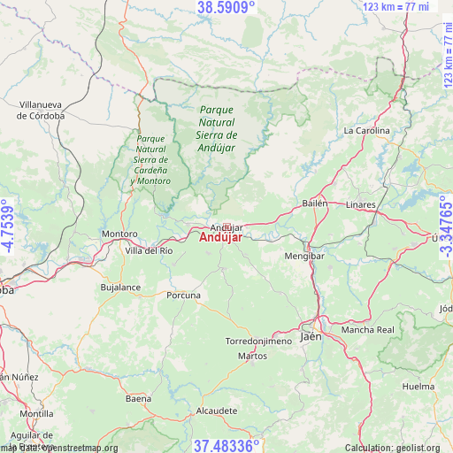
Andújar GPS coordinates[2]
38° 2' 21.192" North, 4° 3' 2.772" West
| Map corner | latitude | longitude |
|---|---|---|
| Upper-left | 38.5909°, | -4.7539° |
| Center: | 38.03922°, | -4.05077° |
| Lower-right: | 37.48336°, | -3.34765° |
| Map W x H: | 123.1×123.1 km | = 76.5×76.5mi |
| max Lat: | 43.74134° ⇑88.3% North |
| Andújar: | 38.03922° |
| min Lat: | ⇓11.7% South 27.64134° |
| min Long | Andújar | max Long |
| -18.00367° | -4.05077° | 4.2899° |
| W 39.4%⇐ | ⇒60.6% E |
Elevation
Elevation of Andújar is 216 m = 709 ft, and this is 382 m = 1253 ft below average elevation for this country.
| Max E: |
1682 m = 5518 ft | 80.2% |
| Avg. | 598 m = 1962 ft | |
| Andújar | 216 m = 709 ft | |
Min E: |
0 m = 0 ft | 19.8% |
See also: Spain elevation on elevation.city.
Geographical zone
Andújar is located in North temperate zone (between Tropic of Cancer and the Arctic Circle). Distance of this Northern Tropic circle is 1623.6 km =1008.9 mi to South.| Distance of | km | miles | from Andújar |
|---|---|---|---|
| North Pole | 5777.5 | 3590 | to North |
| Arctic Circle | 3171.6 | 1970.7 | to North |
| Tropic Cancer | 1623.6 | 1008.9 | to South |
| Equator | 4229.6 | 2628.2 | to South |


Nearby cities:
15 places around Andújar: (largest is in red/bold)
• Arjona
11.6 km =7.2 mi,  181°
181°
• Arjonilla
8.7 km =5.4 mi,  214°
214°
• Bailén
24.7 km =15.3 mi,  75°
75°
• Cazalilla
15.9 km =9.9 mi,  112°
112°
• Escañuela
17.9 km =11.1 mi, 175°
• Espelúy
16.5 km =10.3 mi,  92°
92°
• Fuerte del Rey
23.4 km =14.5 mi,  141°
141°
• Higuera de Arjona
9.3 km =5.8 mi,  145°
145°
• Lopera
17.7 km =11 mi,  234°
234°
• Marmolejo
10.5 km =6.5 mi,  273°
273°
• Mengibar
22.6 km =14 mi, 110°
• Porcuna
22.1 km =13.7 mi, 212°
• Villa del Río
21.9 km =13.6 mi,  252°
252°
• Villanueva de la Reina
12.4 km =7.7 mi, 108°
• Villardompardo
22.9 km =14.2 mi,  168°
168°
Sources, notices
• [Note1] Compared only with cities in Spain existing in our database
• [Src1] Map data: © OpenStreetMap contributors (CC-BY-SA)
• [Src2] Other city data from geonames.org with taken over terms of usage.
• [Src3] Geographical zone / Annual Mean Temperature by Robert A. Rohde @ Wikipedia
