Jamilena geodata
Jamilena (Andalusia) is a seat of a third-order administrative division; located in Spain in Europe/Madrid (GMT+2) time zone. With population of 3,384 people, there are 1611 cities with bigger population in this country. Compared to other cities in Spain, 89.8% of cities are located further ↑North; 58.4% of cities are located further →East and 60.2% of cities have lower elevation than Jamilena. Note1


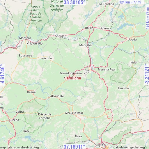
Jamilena GPS coordinates[2]
37° 44' 49.812" North, 3° 54' 51.588" West
| Map corner | latitude | longitude |
|---|---|---|
| Upper-left | 38.30105°, | -4.61746° |
| Center: | 37.74717°, | -3.91433° |
| Lower-right: | 37.18911°, | -3.21121° |
| Map W x H: | 123.6×123.6 km | = 76.8×76.8mi |
| max Lat: | 43.74134° ⇑89.8% North |
| Jamilena: | 37.74717° |
| min Lat: | ⇓10.2% South 27.64134° |
| min Long | Jamilena | max Long |
| -18.00367° | -3.91433° | 4.2899° |
| W 41.6%⇐ | ⇒58.4% E |
Elevation
Elevation of Jamilena is 746 m = 2448 ft, and this is 148 m = 486 ft above average elevation for this country.
| Max E: |
1682 m = 5518 ft | 39.8% |
| Jamilena | 746 m 2448 ft | |
| Avg. | 598 m = 1962 ft | |
Min E: |
0 m = 0 ft | 60.2% |
See also: Spain elevation on elevation.city.
Geographical zone
Jamilena is located in North temperate zone (between Tropic of Cancer and the Arctic Circle). Distance of this Northern Tropic circle is 1591.2 km =988.7 mi to South.| Distance of | km | miles | from Jamilena |
|---|---|---|---|
| North Pole | 5810 | 3610.2 | to North |
| Arctic Circle | 3204.1 | 1990.9 | to North |
| Tropic Cancer | 1591.2 | 988.7 | to South |
| Equator | 4197.1 | 2608 | to South |


Nearby cities:
15 places around Jamilena: (largest is in red/bold)
• Alcaudete
22.8 km =14.2 mi,  220°
220°
• Escañuela
18 km =11.2 mi,  324°
324°
• Fuensanta de Martos
11.1 km =6.9 mi,  177°
177°
• Fuerte del Rey
14.5 km =9 mi,  10°
10°
• Higuera de Calatrava
22.1 km =13.7 mi,  284°
284°
• Jaén
11.2 km =7 mi,  77°
77°
• La Guardia de Jaén
19.5 km =12.1 mi,  91°
91°
• Los Villares
10.4 km =6.5 mi,  126°
126°
• Martos
5.9 km =3.7 mi,  240°
240°
• Pegalajar
23.3 km =14.5 mi, 91°
• Santiago de Calatrava
22.6 km =14 mi,  271°
271°
• Torre del Campo
3 km =1.9 mi,  29°
29°
• Torredonjimeno
4.4 km =2.7 mi,  300°
300°
• Valdepeñas de Jaén
19.7 km =12.2 mi,  153°
153°
• Villardompardo
12.6 km =7.8 mi, 322°
Sources, notices
• [Note1] Compared only with cities in Spain existing in our database
• [Src1] Map data: © OpenStreetMap contributors (CC-BY-SA)
• [Src2] Other city data from geonames.org with taken over terms of usage.
• [Src3] Geographical zone / Annual Mean Temperature by Robert A. Rohde @ Wikipedia
