Fuerte del Rey geodata
Fuerte del Rey (Andalusia) is a seat of a third-order administrative division; located in Spain in Europe/Madrid (GMT+2) time zone. With population of 1,220 people, there are 2710 cities with bigger population in this country. Compared to other cities in Spain, 89.2% of cities are located further ↑North; 58% of cities are located further →East and 67.3% of cities have higher elevation than Fuerte del Rey. Note1


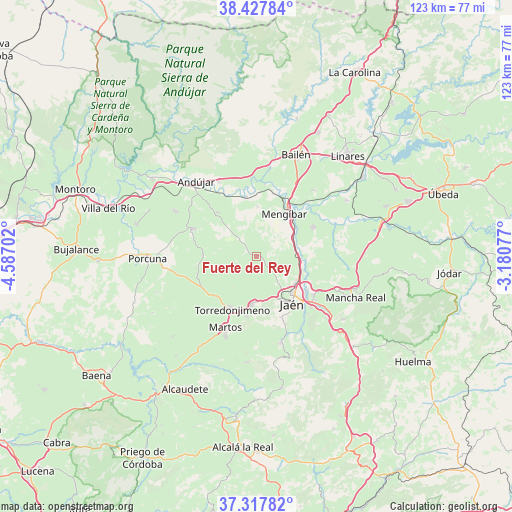
Fuerte del Rey GPS coordinates[2]
37° 52' 29.712" North, 3° 53' 2.004" West
| Map corner | latitude | longitude |
|---|---|---|
| Upper-left | 38.42784°, | -4.58702° |
| Center: | 37.87492°, | -3.88389° |
| Lower-right: | 37.31782°, | -3.18077° |
| Map W x H: | 123.4×123.4 km | = 76.7×76.7mi |
| max Lat: | 43.74134° ⇑89.2% North |
| Fuerte del Rey: | 37.87492° |
| min Lat: | ⇓10.8% South 27.64134° |
| min Long | Fuerte del Rey | max Long |
| -18.00367° | -3.88389° | 4.2899° |
| W 42%⇐ | ⇒58% E |
Elevation
Elevation of Fuerte del Rey is 428 m = 1404 ft, and this is 170 m = 558 ft below average elevation for this country.
| Max E: |
1682 m = 5518 ft | 67.3% |
| Avg. | 598 m = 1962 ft | |
| Fuerte del Rey | 428 m = 1404 ft | |
Min E: |
0 m = 0 ft | 32.7% |
See also: Spain elevation on elevation.city.
Geographical zone
Fuerte del Rey is located in North temperate zone (between Tropic of Cancer and the Arctic Circle). Distance of this Northern Tropic circle is 1605.4 km =997.5 mi to South.| Distance of | km | miles | from Fuerte del Rey |
|---|---|---|---|
| North Pole | 5795.8 | 3601.3 | to North |
| Arctic Circle | 3189.9 | 1982.1 | to North |
| Tropic Cancer | 1605.4 | 997.5 | to South |
| Equator | 4211.3 | 2616.8 | to South |


Nearby cities:
15 places around Fuerte del Rey: (largest is in red/bold)
• Arjona
16.4 km =10.2 mi,  293°
293°
• Cazalilla
12.1 km =7.5 mi,  0°
0°
• Escañuela
13.2 km =8.2 mi,  271°
271°
• Espelúy
17.5 km =10.9 mi,  5°
5°
• Higuera de Arjona
14.2 km =8.8 mi,  318°
318°
• Jabalquinto
21.3 km =13.2 mi,  40°
40°
• Jamilena
14.5 km =9 mi,  190°
190°
• Jaén
14.3 km =8.9 mi,  145°
145°
• Los Villares
21.2 km =13.2 mi,  164°
164°
• Martos
18.8 km =11.7 mi,  204°
204°
• Mengibar
12.4 km =7.7 mi,  31°
31°
• Torre del Campo
11.7 km =7.3 mi, 185°
• Torredonjimeno
13.6 km =8.5 mi,  208°
208°
• Villanueva de la Reina
14.7 km =9.1 mi,  348°
348°
• Villardompardo
11.1 km =6.9 mi,  247°
247°
Sources, notices
• [Note1] Compared only with cities in Spain existing in our database
• [Src1] Map data: © OpenStreetMap contributors (CC-BY-SA)
• [Src2] Other city data from geonames.org with taken over terms of usage.
• [Src3] Geographical zone / Annual Mean Temperature by Robert A. Rohde @ Wikipedia
