Aroche geodata
Aroche (Andalusia) is a seat of a third-order administrative division; located in Spain in Europe/Madrid (GMT+2) time zone. In our database, there are 6762 cities with bigger population. Compared to other cities in Spain, 88.9% of cities are located further ↑North; 94.1% of cities are located further →East and 69.6% of cities have higher elevation than Aroche. Note1


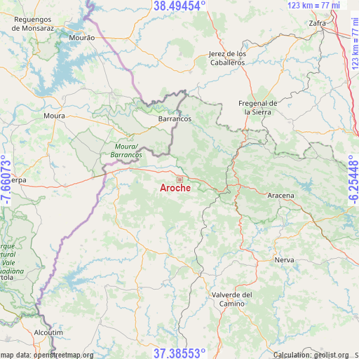
Aroche GPS coordinates[2]
37° 56' 31.668" North, 6° 57' 27.36" West
| Map corner | latitude | longitude |
|---|---|---|
| Upper-left | 38.49454°, | -7.66073° |
| Center: | 37.94213°, | -6.9576° |
| Lower-right: | 37.38553°, | -6.25448° |
| Map W x H: | 123.3×123.3 km | = 76.6×76.6mi |
| max Lat: | 43.74134° ⇑88.9% North |
| Aroche: | 37.94213° |
| min Lat: | ⇓11.1% South 27.64134° |
| min Long | Aroche | max Long |
| -18.00367° | -6.9576° | 4.2899° |
| W 5.9%⇐ | ⇒94.1% E |
Elevation
Elevation of Aroche is 388 m = 1273 ft, and this is 210 m = 689 ft below average elevation for this country.
| Max E: |
1682 m = 5518 ft | 69.6% |
| Avg. | 598 m = 1962 ft | |
| Aroche | 388 m = 1273 ft | |
Min E: |
0 m = 0 ft | 30.4% |
See also: Spain elevation on elevation.city.
Geographical zone
Aroche is located in North temperate zone (between Tropic of Cancer and the Arctic Circle). Distance of this Northern Tropic circle is 1612.9 km =1002.2 mi to South.| Distance of | km | miles | from Aroche |
|---|---|---|---|
| North Pole | 5788.3 | 3596.7 | to North |
| Arctic Circle | 3182.4 | 1977.5 | to North |
| Tropic Cancer | 1612.9 | 1002.2 | to South |
| Equator | 4218.8 | 2621.4 | to South |


Nearby cities:
15 places around Aroche: (largest is in red/bold)
• Alájar
26.7 km =16.6 mi,  106°
106°
• Cabezas Rubias
26.5 km =16.5 mi,  205°
205°
• Cortegana
12.5 km =7.8 mi, 105°
• Cortelazor
29.2 km =18.1 mi,  91°
91°
• Cumbres Mayores
30.4 km =18.9 mi,  64°
64°
• El Cerro de Andévalo
23.1 km =14.4 mi,  175°
175°
• Encinasola
22.8 km =14.2 mi,  20°
20°
• Fuenteheridos
26.3 km =16.3 mi,  98°
98°
• Galaroza
22 km =13.7 mi, 93°
• Jabugo
20.2 km =12.6 mi, 98°
• Linares de la Sierra
30.1 km =18.7 mi, 103°
• Rosal de la Frontera
23.1 km =14.4 mi,  277°
277°
• Santa Ana la Real
22.3 km =13.9 mi, 113°
• Santa Bárbara de Casa
25.9 km =16.1 mi,  231°
231°
• Valdelarco
24.2 km =15 mi, 88°
Sources, notices
• [Note1] Compared only with cities in Spain existing in our database
• [Src1] Map data: © OpenStreetMap contributors (CC-BY-SA)
• [Src2] Other city data from geonames.org with taken over terms of usage.
• [Src3] Geographical zone / Annual Mean Temperature by Robert A. Rohde @ Wikipedia
