Mazarrón geodata
Mazarrón (Murcia) is a seat of a third-order administrative division; located in Spain in Europe/Madrid (GMT+2) time zone. With population of 35,221 people, there are 254 cities with bigger population in this country. Compared to other cities in Spain, 90.8% of cities are located further ↑North; 74.6% of cities are located further ←West and 90% of cities have higher elevation than Mazarrón. Note1


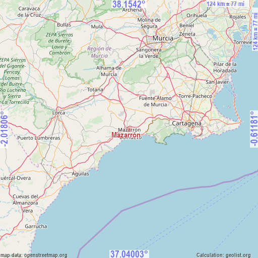
Mazarrón GPS coordinates[2]
37° 35' 57.12" North, 1° 18' 53.748" West
| Map corner | latitude | longitude |
|---|---|---|
| Upper-left | 38.1542°, | -2.01806° |
| Center: | 37.5992°, | -1.31493° |
| Lower-right: | 37.04003°, | -0.61181° |
| Map W x H: | 123.9×123.9 km | = 77×77mi |
| max Lat: | 43.74134° ⇑90.8% North |
| Mazarrón: | 37.5992° |
| min Lat: | ⇓9.2% South 27.64134° |
| min Long | Mazarrón | max Long |
| -18.00367° | -1.31493° | 4.2899° |
| W 74.6%⇐ | ⇒25.4% E |
Elevation
Elevation of Mazarrón is 66 m = 217 ft, and this is 532 m = 1745 ft below average elevation for this country.
| Max E: |
1682 m = 5518 ft | 90% |
| Avg. | 598 m = 1962 ft | |
| Mazarrón | 66 m = 217 ft | |
Min E: |
0 m = 0 ft | 10% |
See also: Spain elevation on elevation.city.
Geographical zone
Mazarrón is located in North temperate zone (between Tropic of Cancer and the Arctic Circle). Distance of this Northern Tropic circle is 1574.7 km =978.5 mi to South.| Distance of | km | miles | from Mazarrón |
|---|---|---|---|
| North Pole | 5826.4 | 3620.4 | to North |
| Arctic Circle | 3220.5 | 2001.1 | to North |
| Tropic Cancer | 1574.7 | 978.5 | to South |
| Equator | 4180.6 | 2597.7 | to South |


Nearby cities:
15 places around Mazarrón: (largest is in red/bold)
• Aledo
31.4 km =19.5 mi,  313°
313°
• Alhama de Murcia
29.6 km =18.4 mi,  340°
340°
• Barrio de la Concepción
27.7 km =17.2 mi,  89°
89°
• Cartagena
29 km =18 mi, 88°
• Cazalla
31.6 km =19.6 mi,  280°
280°
• El Plan
26.9 km =16.7 mi,  77°
77°
• Fuente-Álamo de Murcia
18.9 km =11.7 mi,  42°
42°
• Librilla
32.1 km =19.9 mi,  353°
353°
• Lorca
35 km =21.7 mi, 283°
• Los Gabatos
28 km =17.4 mi, 82°
• Los Martínez
32 km =19.9 mi, 40°
• Torre-Pacheco
35.6 km =22.1 mi,  63°
63°
• Totana
25 km =15.5 mi,  318°
318°
• Valladolises
26 km =16.2 mi, 40°
• Águilas
31.9 km =19.8 mi,  227°
227°
Sources, notices
• [Note1] Compared only with cities in Spain existing in our database
• [Src1] Map data: © OpenStreetMap contributors (CC-BY-SA)
• [Src2] Other city data from geonames.org with taken over terms of usage.
• [Src3] Geographical zone / Annual Mean Temperature by Robert A. Rohde @ Wikipedia
