Gabaldón geodata
Gabaldón (Castille-La Mancha) is a seat of a third-order administrative division; located in Spain in Europe/Madrid (GMT+2) time zone. With population of 198 people, there are 5045 cities with bigger population in this country. Compared to other cities in Spain, 75.5% of cities are located further ↑North; 68.1% of cities are located further ←West and 82.4% of cities have lower elevation than Gabaldón. Note1
Administrative division(s):
- Level 1: Castille-La Mancha
- Level 2: Provincia de Cuenca
- Level 3: Gabaldón


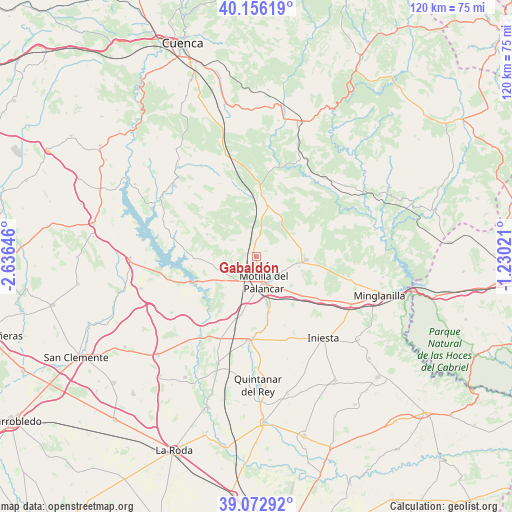
Gabaldón GPS coordinates[2]
39° 37' 0.012" North, 1° 55' 59.988" West
| Map corner | latitude | longitude |
|---|---|---|
| Upper-left | 40.15619°, | -2.63646° |
| Center: | 39.61667°, | -1.93333° |
| Lower-right: | 39.07292°, | -1.23021° |
| Map W x H: | 120.4×120.4 km | = 74.8×74.8mi |
| max Lat: | 43.74134° ⇑75.5% North |
| Gabaldón: | 39.61667° |
| min Lat: | ⇓24.5% South 27.64134° |
| min Long | Gabaldón | max Long |
| -18.00367° | -1.93333° | 4.2899° |
| W 68.1%⇐ | ⇒31.9% E |
Elevation
Elevation of Gabaldón is 921 m = 3022 ft, and this is 323 m = 1060 ft above average elevation for this country.
| Max E: |
1682 m = 5518 ft | 17.6% |
| Gabaldón | 921 m 3022 ft | |
| Avg. | 598 m = 1962 ft | |
Min E: |
0 m = 0 ft | 82.4% |
See also: Spain elevation on elevation.city.
Geographical zone
Gabaldón is located in North temperate zone (between Tropic of Cancer and the Arctic Circle). Distance of this Northern Tropic circle is 1799 km =1117.8 mi to South.| Distance of | km | miles | from Gabaldón |
|---|---|---|---|
| North Pole | 5602.1 | 3481 | to North |
| Arctic Circle | 2996.2 | 1861.8 | to North |
| Tropic Cancer | 1799 | 1117.8 | to South |
| Equator | 4405 | 2737.1 | to South |


Nearby cities:
15 places around Gabaldón: (largest is in red/bold)
• Alarcón
14.8 km =9.2 mi,  240°
240°
• Almodóvar del Pinar
11.9 km =7.4 mi,  21°
21°
• Barchín del Hoyo
12.7 km =7.9 mi,  295°
295°
• Buenache de Alarcón
20.3 km =12.6 mi,  280°
280°
• Campillo de Altobuey
11.6 km =7.2 mi,  99°
99°
• Castillejo de Iniesta
17 km =10.6 mi,  122°
122°
• Chumillas
18.7 km =11.6 mi,  332°
332°
• El Peral
13.3 km =8.3 mi,  167°
167°
• Motilla del Palancar
7 km =4.3 mi,  142°
142°
• Olmedilla de Alarcón
14.3 km =8.9 mi,  270°
270°
• Paracuellos
17 km =10.6 mi,  49°
49°
• Piqueras del Castillo
15.9 km =9.9 mi,  314°
314°
• Valhermoso de la Fuente
9 km =5.6 mi,  232°
232°
• Valverdejo
7.1 km =4.4 mi, 270°
• Villanueva de la Jara
20.4 km =12.7 mi,  180°
180°
Sources, notices
• [Note1] Compared only with cities in Spain existing in our database
• [Src1] Map data: © OpenStreetMap contributors (CC-BY-SA)
• [Src2] Other city data from geonames.org with taken over terms of usage.
• [Src3] Geographical zone / Annual Mean Temperature by Robert A. Rohde @ Wikipedia
